IMAGES TAKEN NEAR TO
Cornhaddock Street, GREENOCK, PA15 4HP
Introduction
This page details the photographs taken nearby to Cornhaddock Street, PA15 4HP by members of the Geograph project.
The Geograph project started in 2005 with the aim of publishing, organising and preserving representative images for every square kilometre of Great Britain, Ireland and the Isle of Man.

There are currently over 7.5m images from over14,400 individuals and you can help contribute to the project by visiting https://www.geograph.org.uk
Image Map
Images are licensed for reuse under creativecommons.org/licenses/by-sa/2.0
Notes
- Clicking on the map will re-center to the selected point.
- The higher the marker number, the further away the image location is from the centre of the postcode.
Image Listing (238 Images Found)
Images are licensed for reuse under creativecommons.org/licenses/by-sa/2.0
Image
Details
Distance
1
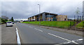
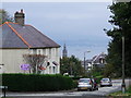
Cornhaddock Street
St Patrick's Primary School is on the right.
Image: © Thomas Nugent
Taken: 17 Jun 2017
0.01 miles
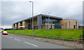
2
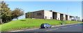
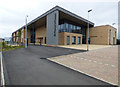
St Patrick's Primary School
The rebuilt school opened in 2017. See the old building here Image
Image: © Thomas Nugent
Taken: 24 Sep 2018
0.02 miles
3
St Patrick's Primary School
The rebuilt school opened in 2017. See the old building here Image
Image: © Thomas Nugent
Taken: 24 Sep 2018
0.02 miles
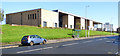
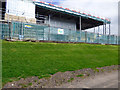
4
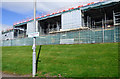
St Patrick's Primary School reconstruction
The old school building was demolished and this new one is taking its place on the same site.
See the old school in 2007 Image
Image: © Thomas Nugent
Taken: 17 Apr 2016
0.02 miles
5
St Patrick's Primary School reconstruction
The Cornhaddock Street side of the new building.
See the old building here Image
Image: © Thomas Nugent
Taken: 17 Apr 2016
0.03 miles
6
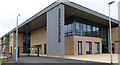
St Patrick's Primary School
A new school building on the site of the old.
See the old building here Image
Image: © Thomas Nugent
Taken: 17 Jun 2017
0.04 miles
7
St Patrick's Primary School
A new school building on the site of the old.
See the old building here Image
Image: © Thomas Nugent
Taken: 17 Jun 2017
0.04 miles
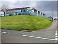
8
Dunn Street
Note the sunken ship in the Clyde in the distance. Sugar boat Captayannis struck a sandbank and sunk in the early 1970s. More information here http://www.clydesite.co.uk/articles/captayannis.asp
Image: © Thomas Nugent
Taken: 21 Oct 2007
0.04 miles
9
St Patrick's Primary School
The Cornhaddock Street side of the school.
Image: © Thomas Nugent
Taken: 17 Jun 2017
0.05 miles
10
St Patrick's Primary School reconstruction
The Cornhaddock Street side of the new building.
See the old building here Image
Image: © Thomas Nugent
Taken: 17 Apr 2016
0.05 miles