IMAGES TAKEN NEAR TO
Ann Street, GREENOCK, PA15 4EL
Introduction
This page details the photographs taken nearby to Ann Street, PA15 4EL by members of the Geograph project.
The Geograph project started in 2005 with the aim of publishing, organising and preserving representative images for every square kilometre of Great Britain, Ireland and the Isle of Man.

There are currently over 7.5m images from over14,400 individuals and you can help contribute to the project by visiting https://www.geograph.org.uk
Image Map (Loading...)


Getting Data...Please wait
Leaflet Map data © OpenStreetMap
Images are licensed for reuse under creativecommons.org/licenses/by-sa/2.0
Notes
- Clicking on the map will re-center to the selected point.
- The higher the marker number, the further away the image location is from the centre of the postcode.
Image Listing (332 Images Found)
Images are licensed for reuse under creativecommons.org/licenses/by-sa/2.0
Image
Details
Distance
1
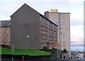
Ann Street
Looking down the hill from Nile Street.
Image: © Thomas Nugent
Taken: 4 Dec 2012
0.01 miles
2
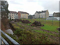
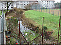
Water channel at Dempster Street
Looking into the channel from Nile Street, with Dempster Street and Trafalgar Street beyond. Dredging work is taking place, evidenced by the heaps on the right. Part of the Shaws Water Scheme.
Image: © Thomas Nugent
Taken: 21 Nov 2020
0.01 miles
3
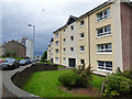
Renovated flats on Ann Street
At the corner of Nile Street.
See also Image
Image: © Thomas Nugent
Taken: 17 Jun 2017
0.02 miles
4
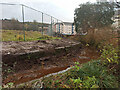
Shaws Water Works
This exposed section is viewed from Nile Street, with Ann Street on the left and Dempster Street on the right.
Image: © Thomas Nugent
Taken: 27 Jan 2015
0.02 miles
5
Shaws Water Works
This exposed section is viewed from Nile Street, with Dempster Street in the background.
Image: © Thomas Nugent
Taken: 27 Jan 2015
0.02 miles
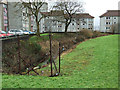
6
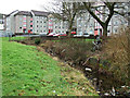
Water channel at Dempster Street
Ann Street is on the right. Dredging work is taking place. Part of the Shaws Water Scheme.
Image: © Thomas Nugent
Taken: 21 Nov 2020
0.02 miles
7
Shaws Water Works
This exposed section is viewed looking towards Nile Street, with Ann Street on the right.
Image: © Thomas Nugent
Taken: 27 Jan 2015
0.03 miles
8
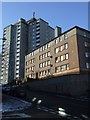
Ann Street
Ann Street runs up the steep hill from Sir Michael Street in the town centre to Drumfrochar Road. Seen here at the junction with Dempster Street.
Image: © Thomas Nugent
Taken: 11 Feb 2009
0.03 miles
9
Ann Street
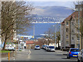
Looking down the hill from Drumfrochar Road. Helensburgh can be seen across the Firth of Clyde.
Image: © Thomas Nugent
Taken: 17 Apr 2016
0.03 miles
10
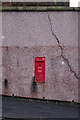
G vi R post box
On Ann Street, at Dempster Street.
Image: © Thomas Nugent
Taken: 4 Dec 2012
0.03 miles