IMAGES TAKEN NEAR TO
Luss Place, GREENOCK, PA15 3EP
Introduction
This page details the photographs taken nearby to Luss Place, PA15 3EP by members of the Geograph project.
The Geograph project started in 2005 with the aim of publishing, organising and preserving representative images for every square kilometre of Great Britain, Ireland and the Isle of Man.

There are currently over 7.5m images from over14,400 individuals and you can help contribute to the project by visiting https://www.geograph.org.uk
Image Map (Loading...)


Getting Data...Please wait
Leaflet Map data © OpenStreetMap
Images are licensed for reuse under creativecommons.org/licenses/by-sa/2.0
Notes
- Clicking on the map will re-center to the selected point.
- The higher the marker number, the further away the image location is from the centre of the postcode.
Image Listing (21 Images Found)
Images are licensed for reuse under creativecommons.org/licenses/by-sa/2.0
Image
Details
Distance
1
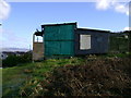
Doocot perched above housing estate
This doocot is on some marginal land between a residential area and rough grazing land.
Image: © Mark Nightingale
Taken: 5 Feb 2007
0.12 miles
2
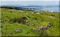
The ruins of Loudenward Farm
For the main description of the ruined farm building, see Image The present photograph shows an additional small structure that is located at the north-eastern corner of the main building.
Behind the unconcerned sheep, the town of Greenock can be seen on the shore.
Image: © Lairich Rig
Taken: 4 Jul 2011
0.14 miles
3
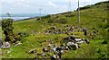
The ruins of Loudenward Farm
I had previously seen the field system associated with the farm, but not the ruined farm building itself. For images of the field system, click on the title of the end-note.
The farm was in existence in the seventeenth century, and is mentioned by Archibald Brown in "The Early Annals of Greenock" (1905). In the section describing Lady Kilbirnie's sale of Easter Greenock to Sir John Shaw/Schaw in 1667, he quotes "this little farm or croft called Loudoun Ward is thirteen acres in extent. The possessor has the privilege of ish and entry through Sir John's property, also to cast peats and graze six cows beyond the bounds; he pays rent to Mr. Crawfurd of Carsburn; the latter has the right of shooting over the hills of Easter Greenock" ["ish" is the right of egress; "Carsburn": Cartsburn; "Mr Crawfurd": Thomas Crawfurd, Lady Kilbirnie's cousin].
The same work allows the ultimate origin of the farm's name to be inferred: "Malcolm Galbraith, heir of Greenock and the last of the race, died without male issue, but left two daughters. The elder of them married a Malcolm Crawfurd, of the family of Loudoun, who acquired by her the lands of Easter Greenock"; this was about the time of King Robert III (i.e., around 1400). For the place Loudoun, where this branch of the Crawfurds originated, see the 1:25000 map for Image
For the main description of the farm's situation, and its representation on old maps, see Image
The present photograph is a view of the ruined farm building itself. The building is aligned W-E, and the photograph is a view directly along its length, with the western wall (one of the short walls) in the foreground. When the building is examined on the ground, a cross-wall is evident, which divided this building into two rooms. The foundations of an additional structure could be seen at the north-eastern corner of this building: Image
Image: © Lairich Rig
Taken: 4 Jul 2011
0.14 miles
4
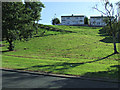
Houses on Leven Road
Viewed from Kilmacolm Road.
Image: © Thomas Nugent
Taken: 7 Sep 2014
0.16 miles
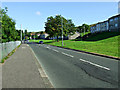
5
Kilmacolm Road
The B788 road, climbing through the east end of Greenock.
Image: © Thomas Nugent
Taken: 7 Sep 2014
0.18 miles
6
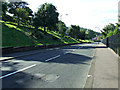
Kilmacolm Road
The B788 road, descending into Greenock.
Image: © Thomas Nugent
Taken: 7 Sep 2014
0.19 miles
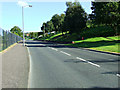
7
Kilmacolm Road
The B788 climbing through the east end of Greenock.
Image: © Thomas Nugent
Taken: 7 Sep 2014
0.19 miles
8
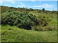
Bomb crater
The vegetation makes it harder to discern from a photograph that this is a neat circular pit. Note the old trough on the far (western) side.
There are probably other craters in the area; I encountered this one soon after leaving the track that is marked on the map.
Image: © Lairich Rig
Taken: 24 Jul 2017
0.20 miles
9
Outcrop, potential site of TP15796 Loudenward
No evidence of OS surface block, top soil not deep enough for it to be buried.
Image: © cowboycoder
Taken: 13 Sep 2021
0.21 miles
10
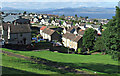
Greenock east end
Looking over the east end from Kilmacolm Road, with Helensburgh and the Firth of Clyde in the distance.
Image: © Thomas Nugent
Taken: 7 Sep 2014
0.22 miles