IMAGES TAKEN NEAR TO
Carwood Street, GREENOCK, PA15 2EP
Introduction
This page details the photographs taken nearby to Carwood Street, PA15 2EP by members of the Geograph project.
The Geograph project started in 2005 with the aim of publishing, organising and preserving representative images for every square kilometre of Great Britain, Ireland and the Isle of Man.

There are currently over 7.5m images from over14,400 individuals and you can help contribute to the project by visiting https://www.geograph.org.uk
Image Map (Loading...)


Getting Data...Please wait
Leaflet Map data © OpenStreetMap
Images are licensed for reuse under creativecommons.org/licenses/by-sa/2.0
Notes
- Clicking on the map will re-center to the selected point.
- The higher the marker number, the further away the image location is from the centre of the postcode.
Image Listing (469 Images Found)
Images are licensed for reuse under creativecommons.org/licenses/by-sa/2.0
Image
Details
Distance
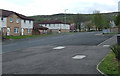
1
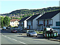
Carwood Street
Looking towards Sinclair Street.
Image: © Thomas Nugent
Taken: 7 Sep 2014
0.01 miles
2
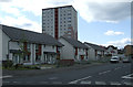
Carwood Street
The street and houses have changed considerably in recent years. Sinclair Street is in the foreground.
Image: © Thomas Nugent
Taken: 28 Apr 2012
0.01 miles
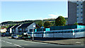
3
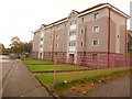
Greenock: disused flats await their fate
The majority of the windows and doors in this block of flats are boarded up; the rest are smashed. The block awaits the final chapter in its history – demolition, I would imagine – along with a few neighbouring blocks.
Image: © Chris Downer
Taken: 10 Oct 2009
0.03 miles
4
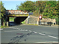
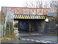
Sinclair Street railway bridge
This low and narrow bridge carries the Glasgow to Gourock line over Sinclair Street.
Image: © Thomas Nugent
Taken: 7 Sep 2014
0.03 miles
5
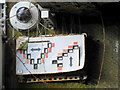
Sinclair Street railway bridge
The south side of the bridge, which carries the Gourock branch of the Inverclyde Line over Sinclair Street.
The solar panels provide power to collision detection system within the bridge Image, Image
Image: © Thomas Nugent
Taken: 22 Feb 2019
0.03 miles
6
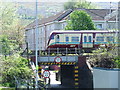
Sinclair Street
A Gourock bound train crosses the low, narrow Sinclair St railway bridge.
Image: © Thomas Nugent
Taken: 30 Apr 2007
0.03 miles
7
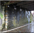
Sinclair Street railway bridge
CCTV cameras and tell-tale devices Image to detect movement of the bridge structure can be seen at the top of the wall. The cameras are monitoring devices on the opposite of the road.
The road surface has been changed to mono block since this photo was taken, but there is still no footpath on either side of the road through the narrow bridge. The bridge carries the Gourock branch of the Inverclyde Line.
Image: © Thomas Nugent
Taken: 22 Feb 2019
0.03 miles
8
Sinclair Street railway bridge
One of several CCTV cameras and tell-tale devices Image to detect movement of the bridge structure. The camera is monitoring a device similar to the one shown here, but on the opposite side of the road. The bridge carries the Gourock branch of the Inverclyde Line.
Image: © Thomas Nugent
Taken: 22 Feb 2019
0.03 miles
9
Sinclair Street
At the junction with Carwood Street.
Image: © Thomas Nugent
Taken: 28 Apr 2012
0.03 miles
10
Carwood Street
Looking towards Sinclair Street at Baxter Street.
Image: © Thomas Nugent
Taken: 7 Sep 2014
0.04 miles