IMAGES TAKEN NEAR TO
East Crawford Street, GREENOCK, PA15 2EA
Introduction
This page details the photographs taken nearby to East Crawford Street, PA15 2EA by members of the Geograph project.
The Geograph project started in 2005 with the aim of publishing, organising and preserving representative images for every square kilometre of Great Britain, Ireland and the Isle of Man.

There are currently over 7.5m images from over14,400 individuals and you can help contribute to the project by visiting https://www.geograph.org.uk
Image Map
Images are licensed for reuse under creativecommons.org/licenses/by-sa/2.0
Notes
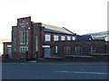
- Clicking on the map will re-center to the selected point.
- The higher the marker number, the further away the image location is from the centre of the postcode.
Image Listing (162 Images Found)
Images are licensed for reuse under creativecommons.org/licenses/by-sa/2.0
Image
Details
Distance
1
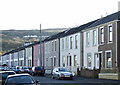
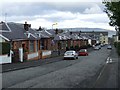
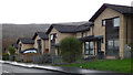
Octavia Cottages
On East Crawford Street. This row of cottages provides a pleasant change to the drab tenements and high rises of the east end.
Image: © Thomas Nugent
Taken: 23 Nov 2007
0.02 miles
2
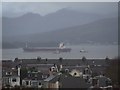
Ship at The Tail O' The Bank
A ship of the Maersk Line being prepared for tow to The Great harbour by two tugs. The houses in the foreground are at Bridgend, the mountains are in Argyll.
Image: © Thomas Nugent
Taken: 23 Nov 2009
0.05 miles
3
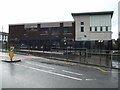
Kings Oak Nursery School
On Grosvenor Road.
Image: © Thomas Nugent
Taken: 23 Nov 2009
0.07 miles
4
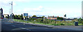
Bridgend Road
Looking towards Grosvenor Road.
Image: © Thomas Nugent
Taken: 7 Sep 2014
0.07 miles
5
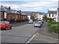
Border Street
Looking towards East Crawford Street. National Cycle Network Route 75 runs along this street and also Morris Street which is to the right.
Image: © Thomas Nugent
Taken: 27 Feb 2009
0.07 miles
6
Gap site at East Crawford Street
The site of tenements which ran from Craigieknowes Street to Bawhirley Road. The edge of one of the tenements can be seen in this photo from 2009 Image (the white building).
Image: © Thomas Nugent
Taken: 7 Sep 2014
0.07 miles
7
Border Street
Residential street, Bridgend. Used by National Cycle Network Route 75.
Image: © Richard Webb
Taken: 22 Jun 2009
0.09 miles
8
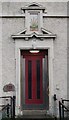
49 Grosvenor Road
A splash of colour above the door of an otherwise drab tenement.
Image: © Thomas Nugent
Taken: 23 Nov 2009
0.09 miles
9
The Salvation Army
On the lower part of Bawhirley Road in the east end of Greenock.
Image: © Thomas Nugent
Taken: 23 Nov 2007
0.11 miles
10
Auchendarroch Street
Near the Bawhirley Road junction.
Image: © Thomas Nugent
Taken: 22 Feb 2019
0.11 miles