IMAGES TAKEN NEAR TO
Langbank, PORT GLASGOW, PA14 6YR
Introduction
This page details the photographs taken nearby to PA14 6YR by members of the Geograph project.
The Geograph project started in 2005 with the aim of publishing, organising and preserving representative images for every square kilometre of Great Britain, Ireland and the Isle of Man.

There are currently over 7.5m images from over14,400 individuals and you can help contribute to the project by visiting https://www.geograph.org.uk
Image Map
Images are licensed for reuse under creativecommons.org/licenses/by-sa/2.0
Notes
- Clicking on the map will re-center to the selected point.
- The higher the marker number, the further away the image location is from the centre of the postcode.
Image Listing (11 Images Found)
Images are licensed for reuse under creativecommons.org/licenses/by-sa/2.0
Image
Details
Distance
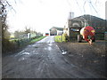
2
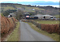
Bogside Farm Langbank
Bogside Farm fantastic views of the Clyde.
Langbank
Port Glasgow
PA14 6YR
If you’ve never visited Langbank on the River Clyde, you should. Just walk out of the train station and head up into the hill till you meet a fork in the road and go right along the old Greenock road where you won't be disappointed with the fantastic views it and Langbank have to offer.
More Langbank photos taken September 5th 2015 here : https://www.flickr.com/photos/its-all-pretty-cool_dot-com/albums/72157658254115372
Image: © david cameron photographer
Taken: 5 Sep 2015
0.03 miles
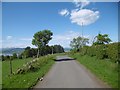
3
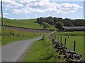
Lane, Bogside
Cattle country in Renfrewshire, a steep climb above Langbank.
Image: © Richard Webb
Taken: 2 Jun 2016
0.09 miles
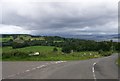
4
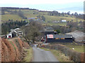
Galahill Road
Looking down the hill to Bogside Farm, with Burnside Farm in the distance.
Image: © Thomas Nugent
Taken: 2 Apr 2018
0.10 miles
5
Galahill Road
Looking down the hill to Bogside Farm, with Burnside Farm in the distance.
Image: © Thomas Nugent
Taken: 2 Apr 2018
0.10 miles
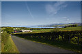
6
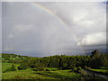
Sunshine and Showers
Fields at Bogside farm lit by the early morning sun, the woodland is Damhead plantation. The picture was taken looking northwest across the Clyde from the junction of Old Greenock Road and Bogside Farm.
Image: © Chris Court
Taken: 25 Sep 2005
0.14 miles
7
Yellow road, Bogside, Langbank
Looking towards the junction with the Old Greenock Road.
Image: © Richard Webb
Taken: 2 Jun 2016
0.17 miles
8
Junction of Old Greenock Road and Gallahill Road
Image: © Elliott Simpson
Taken: 13 Aug 2016
0.18 miles
9
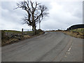
Old Greenock Road
Near the top of the hill at the junction with Galahill Road.
Image: © Thomas Nugent
Taken: 2 Apr 2018
0.18 miles
10
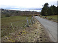
Old Greenock Road
Looking down the hill towards Finlaystone from Galahill Road.
Image: © Thomas Nugent
Taken: 2 Apr 2018
0.19 miles