IMAGES TAKEN NEAR TO
Dennistoun Road, PORT GLASGOW, PA14 6XH
Introduction
This page details the photographs taken nearby to Dennistoun Road, PA14 6XH by members of the Geograph project.
The Geograph project started in 2005 with the aim of publishing, organising and preserving representative images for every square kilometre of Great Britain, Ireland and the Isle of Man.

There are currently over 7.5m images from over14,400 individuals and you can help contribute to the project by visiting https://www.geograph.org.uk
Image Map
Images are licensed for reuse under creativecommons.org/licenses/by-sa/2.0
Notes
- Clicking on the map will re-center to the selected point.
- The higher the marker number, the further away the image location is from the centre of the postcode.
Image Listing (62 Images Found)
Images are licensed for reuse under creativecommons.org/licenses/by-sa/2.0
Image
Details
Distance
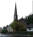
1
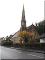
Langbank Parish Church
In the middle of the old village overlooking the Clyde.
Image: © James Denham
Taken: 24 Nov 2013
0.08 miles
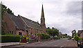
2
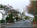
Main Road, Langbank
Looking west towards the church.
Image: © Thomas Nugent
Taken: 8 Nov 2007
0.08 miles
3
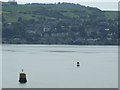
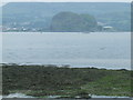
Langbank from Dumbarton Rock
Viewed from Dumbarton Rock.
Image: © Thomas Nugent
Taken: 12 Jul 2013
0.08 miles
4
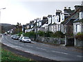
Main Road, Langbank
Main Road bordered the River Clyde until the A8 was re-aligned on reclaimed land in the mid 1970s. As a result, most of the houses are on the south side of the road.
Image: © Thomas Nugent
Taken: 8 Nov 2007
0.09 miles
5
Langbank Church
Church of Scotland on Main Road. See the former Langbank East Church here Image
Image: © Thomas Nugent
Taken: 8 Nov 2007
0.09 miles
6
Langbank Church
Sits beside the B789. Church of Scotland.
Image: © wfmillar
Taken: 16 Jun 2011
0.09 miles
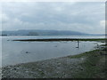
7

Timber ponds and Langbank
Viewed from a sandbank to the east of Finlaystone Burn.
Image: © Thomas Nugent
Taken: 6 Jun 2008
0.14 miles
8
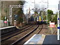
Train approaching Langbank station
Scotrail Class 380 train number 380 012 approaching with a stopping service from Gourock to Glasgow Central.
Image: © Thomas Nugent
Taken: 27 Feb 2017
0.14 miles
9
Langbank west crannog
By the A8 dual carriageway which bypasses Langbank. Langbank east crannog is around a mile upstream at Westferry Image
A crannog is an ancient dwellinghouse (up to 5000 years old) on stilts on a man-made island, the term is also used to describe the island which is typically all that remains today.
More information from this http://www.crannog.co.uk
Image: © Thomas Nugent
Taken: 6 Jun 2008
0.17 miles
10
Langbank west crannog
Dumbarton Rock is prominent across the Clyde.
A crannog is an ancient dwellinghouse (up to 5000 years old) on stilts on a man-made island, the term is also used to describe the island which is typically all that remains today.
More information from this http://www.crannog.co.uk
Image: © Thomas Nugent
Taken: 6 Jun 2008
0.17 miles