IMAGES TAKEN NEAR TO
Mid Avenue, PORT GLASGOW, PA14 6PL
Introduction
This page details the photographs taken nearby to Mid Avenue, PA14 6PL by members of the Geograph project.
The Geograph project started in 2005 with the aim of publishing, organising and preserving representative images for every square kilometre of Great Britain, Ireland and the Isle of Man.

There are currently over 7.5m images from over14,400 individuals and you can help contribute to the project by visiting https://www.geograph.org.uk
Image Map
Images are licensed for reuse under creativecommons.org/licenses/by-sa/2.0
Notes
- Clicking on the map will re-center to the selected point.
- The higher the marker number, the further away the image location is from the centre of the postcode.
Image Listing (143 Images Found)
Images are licensed for reuse under creativecommons.org/licenses/by-sa/2.0
Image
Details
Distance
1
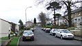
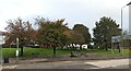
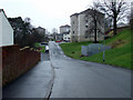
Northfield Avenue
Mature trees amongst the houses near the rear gate of Holy Family Church.
Image: © Thomas Nugent
Taken: 10 Mar 2012
0.06 miles
2
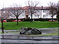
The Bogle Stone
Carried down Loch Long during the Ice Age and deposited near the top of the Clune Brae. Bogle is Scots for ghost and local legend states that a church minister once tried to blow up the stone with dynamite.
Image: © Thomas Nugent
Taken: 8 Jan 2007
0.06 miles
3
The Bogle Stone
Carried down Loch Long during the Ice Age and deposited near the top of the Clune Brae. Bogle is Scots for ghost and local legend states that a church minister once tried to blow up the stone with dynamite.
Image: © Thomas Nugent
Taken: 8 Jan 2007
0.09 miles
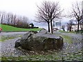
4
The Bogle Stone
By the A761 Kilmacolm Road near Boglestone Roundabout. Carried down Loch Long during the Ice Age and deposited near the top of the Clune Brae. Bogle is Scots for ghost and local legend states that a church minister once tried to blow up the stone with dynamite.
Image: © Thomas Nugent
Taken: 27 Feb 2012
0.09 miles
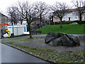
5
The Bogle Stone
The stone was carried down Loch Long during the Ice Age and deposited near the top of the Clune Brae. Bogle is Scots for ghost and local legend states that a church minister once tried to blow up the stone with dynamite. Located beside the A761 Clune Brae, near Boglestone Roundabout.
Image: © Thomas Nugent
Taken: 8 Oct 2022
0.10 miles
6
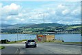
The Highlands and River Clyde
Seen from the A761 Kilmacolm Road. A stunning view despite the Fort Apache style Chinese takeaway which was originally a BP petrol station. The peak of Ben Lomond can just be seen in the distance.
Image: © Thomas Nugent
Taken: 25 Jul 2009
0.10 miles
7
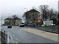
A761 Kilmacolm Road
Just below Boglestone Roundabout.
Image: © Thomas Nugent
Taken: 27 Feb 2012
0.10 miles
8
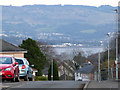
Helensburgh and Glen Fruin from Port Glasgow
Viewed from Kilmacolm Road. The houses are on Southfield Avenue.
Image: © Thomas Nugent
Taken: 6 Jan 2011
0.10 miles
9
Brookfield Road
Between Kilmacolm Road and High Carnagie Road.
Image: © Thomas Nugent
Taken: 27 Feb 2012
0.11 miles
10
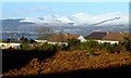
Southfield Avenue
Looking down Southfield Avenue to Broadfield Avenue, with the River Clyde, Dumbarton and Kilpatrick Hills in the distance.
Image: © Thomas Nugent
Taken: 7 Feb 2020
0.12 miles