IMAGES TAKEN NEAR TO
Skye Road, PORT GLASGOW, PA14 6EQ
Introduction
This page details the photographs taken nearby to Skye Road, PA14 6EQ by members of the Geograph project.
The Geograph project started in 2005 with the aim of publishing, organising and preserving representative images for every square kilometre of Great Britain, Ireland and the Isle of Man.

There are currently over 7.5m images from over14,400 individuals and you can help contribute to the project by visiting https://www.geograph.org.uk
Image Map
Images are licensed for reuse under creativecommons.org/licenses/by-sa/2.0
Notes
- Clicking on the map will re-center to the selected point.
- The higher the marker number, the further away the image location is from the centre of the postcode.
Image Listing (52 Images Found)
Images are licensed for reuse under creativecommons.org/licenses/by-sa/2.0
Image
Details
Distance
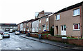
1
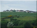
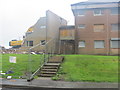
Park Farm
A council housing scheme in upper Port Glasgow. Viewed from Finlaystone Road at Auchendores Reservoir.
Image: © Thomas Nugent
Taken: 6 Jun 2008
0.05 miles
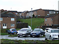
3
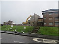
Demolition of flats in Oronsay Avenue Port Glasgow
Image: © John Ferguson
Taken: 17 Aug 2012
0.07 miles
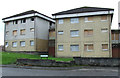
4
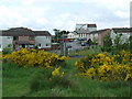
Oronsay Avenue
Viewed from the dirt path from Castlehill Farm Road. The white building with the long windows in the centre is Ambassador Hall.
Image: © Thomas Nugent
Taken: 6 Jun 2008
0.08 miles
5
Demolition of flats in Oronsay Avenue Port Glasgow
Image: © John Ferguson
Taken: 17 Aug 2012
0.08 miles
6
Oronsay Avenue
Part of the "banana block", a row of ten linked blocks of flats, built in the late 1960s, which is currently being demolished. These two are at the junction of Pladda Avenue.
Image: © Thomas Nugent
Taken: 26 Aug 2012
0.11 miles
7
Rona Avenue
Viewed from the Oronsay Avenue end.
Image: © Thomas Nugent
Taken: 6 Jun 2008
0.11 miles
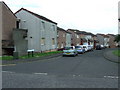
8
Oronsay Avenue
Looking towards Pladda Avenue.
Image: © Thomas Nugent
Taken: 6 Jun 2008
0.11 miles
9
Stroma Avenue
Looking into Stroma Avenue from Oronsay Avenue.
Image: © Thomas Nugent
Taken: 27 Feb 2012
0.14 miles
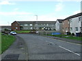
10
Oronsay Avenue
With Westray Avenue on the hill beyond. The "zig-zag" path used to run up the grassed area in the centre.
Image: © Thomas Nugent
Taken: 27 Feb 2012
0.15 miles