IMAGES TAKEN NEAR TO
Oronsay Avenue, PORT GLASGOW, PA14 6DY
Introduction
This page details the photographs taken nearby to Oronsay Avenue, PA14 6DY by members of the Geograph project.
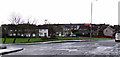
The Geograph project started in 2005 with the aim of publishing, organising and preserving representative images for every square kilometre of Great Britain, Ireland and the Isle of Man.

There are currently over 7.5m images from over14,400 individuals and you can help contribute to the project by visiting https://www.geograph.org.uk
Image Map
Images are licensed for reuse under creativecommons.org/licenses/by-sa/2.0
Notes
- Clicking on the map will re-center to the selected point.
- The higher the marker number, the further away the image location is from the centre of the postcode.
Image Listing (79 Images Found)
Images are licensed for reuse under creativecommons.org/licenses/by-sa/2.0
Image
Details
Distance
1
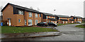
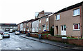
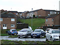
New houses off Oronsay Avenue
Between Oronsay Avenue and Staffa Avenue.
Image: © Thomas Nugent
Taken: 27 Feb 2012
0.03 miles
2
New houses off Oronsay Avenue
Built on former marshland between Oronsay Avenue and Staffa Avenue. Viewed from Oronsay Avenue.
Image: © Thomas Nugent
Taken: 27 Feb 2012
0.03 miles
3
Stroma Avenue
Looking into Stroma Avenue from Oronsay Avenue.
Image: © Thomas Nugent
Taken: 27 Feb 2012
0.04 miles
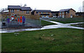
4
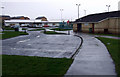
Park Farm Community Hall
With the Rainbow Family Centre in the background.
Image: © Thomas Nugent
Taken: 27 Feb 2012
0.04 miles
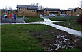
5
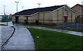
Park Farm Community Hall
On Oronsay Avenue.
Image: © Thomas Nugent
Taken: 27 Feb 2012
0.04 miles
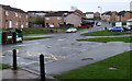
6
Mull Avenue
Oronsay Avenue is on the left, the new houses are on Mull Avenue and Tiree Avenue on the right.
Image: © Thomas Nugent
Taken: 27 Feb 2012
0.05 miles
7
Monach Road
The houses in the background are on Monach Road, viewed across the crossroads at Mull Avenue, Oronsay Avenue and Tiree Avenue.
Image: © Thomas Nugent
Taken: 27 Feb 2012
0.06 miles
8
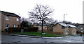
Oronsay Avenue
With Westray Avenue on the hill beyond. The "zig-zag" path used to run up the grassed area in the centre.
Image: © Thomas Nugent
Taken: 27 Feb 2012
0.07 miles