IMAGES TAKEN NEAR TO
Cumbrae Avenue, PORT GLASGOW, PA14 6BE
Introduction
This page details the photographs taken nearby to Cumbrae Avenue, PA14 6BE by members of the Geograph project.
The Geograph project started in 2005 with the aim of publishing, organising and preserving representative images for every square kilometre of Great Britain, Ireland and the Isle of Man.

There are currently over 7.5m images from over14,400 individuals and you can help contribute to the project by visiting https://www.geograph.org.uk
Image Map (Loading...)


Getting Data...Please wait
Leaflet Map data © OpenStreetMap
Images are licensed for reuse under creativecommons.org/licenses/by-sa/2.0
Notes
- Clicking on the map will re-center to the selected point.
- The higher the marker number, the further away the image location is from the centre of the postcode.
Image Listing (49 Images Found)
Images are licensed for reuse under creativecommons.org/licenses/by-sa/2.0
Image
Details
Distance
1
Inverclyde waterfront 1987
Taken from the fields at Pladda Avenue around 1987 when the Kingston and Glen shipyards were still in existence. Note the Goliath Crane at the Glen Yard where Tesco now stands and the two oil rigs; Ocean Alliance which is at the Great Harbour having been recently launched from the Glen Yard and another unknown rig at what is now Greenock Ocean Terminal. That rig can be seen here Image
Image: © Thomas Nugent
Taken: Unknown
0.10 miles
2
Inverclyde waterfront 1987
Taken from the fields at Pladda Avenue around 1987 when the Kingston and Glen shipyards were still in existence, as was the Holy Family Primary School in the left foreground. Note the Goliath Crane at the Glen Yard where Tesco now stands and the two oil rigs; Ocean Alliance which is at the Great Harbour having been recently launched from the Glen Yard and another unknown rig at what is now Greenock Ocean Terminal. That rig can be seen here Image
Image: © Thomas Nugent
Taken: Unknown
0.10 miles
3
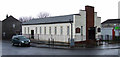
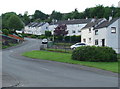
Struthers Memorial Church
On Arran Avenue, at Gallahill Avenue.
Image: © Thomas Nugent
Taken: 27 Feb 2012
0.11 miles
4
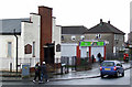
Park Farm Post Office
On Arran Avenue, by Struthers Memorial Church.
Image: © Thomas Nugent
Taken: 27 Feb 2012
0.11 miles
5
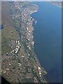
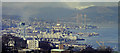
Port Glasgow and Greenock from the air
Port Glasgow is in the lower half of the photo, Greenock in the upper half. Kelburn industrial estate is in the lower right corner, Port Glasgow industrial estate is near the centre. The Great Harbour at Greenock is prominent, with James Watt Dock, Victoria Harbour and East India Harbour beyond. Gourock Bay can also be seen in the distance, as can the tip of the Rosneath peninsula.
Image: © Thomas Nugent
Taken: 14 Sep 2015
0.11 miles
6
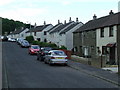
Arran Avenue
At the junction with Parkhill Avenue.
Image: © Thomas Nugent
Taken: 6 Jun 2008
0.11 miles
8

Bute Avenue
Cardross and the River Clyde are visible in the distance.
Image: © Thomas Nugent
Taken: 6 Jun 2008
0.14 miles
9
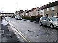
Mull Avenue
Looking up the hill towards Islay Avenue from Tiree Avenue.
Image: © Thomas Nugent
Taken: 27 Feb 2012
0.16 miles
10
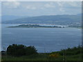
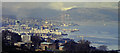
Helensburgh and Ardmore Peninsula
Viewed from the fields at Pladda Avenue.
Image: © Thomas Nugent
Taken: 6 Jun 2008
0.17 miles