IMAGES TAKEN NEAR TO
Morrison Drive, PORT GLASGOW, PA14 6AJ
Introduction
This page details the photographs taken nearby to Morrison Drive, PA14 6AJ by members of the Geograph project.
The Geograph project started in 2005 with the aim of publishing, organising and preserving representative images for every square kilometre of Great Britain, Ireland and the Isle of Man.

There are currently over 7.5m images from over14,400 individuals and you can help contribute to the project by visiting https://www.geograph.org.uk
Image Map (Loading...)


Getting Data...Please wait
Leaflet Map data © OpenStreetMap
Images are licensed for reuse under creativecommons.org/licenses/by-sa/2.0
Notes
- Clicking on the map will re-center to the selected point.
- The higher the marker number, the further away the image location is from the centre of the postcode.
Image Listing (74 Images Found)
Images are licensed for reuse under creativecommons.org/licenses/by-sa/2.0
Image
Details
Distance
1
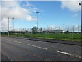
St Stephen's High School, Port Glasgow
From Kilmacolm Road.
Image: © Stephen Sweeney
Taken: 26 Sep 2011
0.04 miles
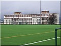
2
Port Glasgow, St. Stephen's High School
Under repair ?
Image: © william craig
Taken: 16 Oct 2005
0.04 miles
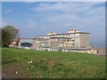
3
Saint Stephen's High School
See Image] for a picture of the building before repairs were carried out. The views of Argyll, the Clyde and Ben Lomond from the top floor of this school are simply breathtaking and provide an interesting distraction from lessons.
Image: © Thomas Nugent
Taken: 8 Jan 2007
0.05 miles
4
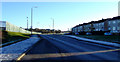
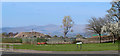
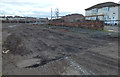
Site of St Stephen's High School
The school was demolished after the new Port Glasgow Community Campus opened. Houses are being built here now.
See the building in 2007 Image
Image: © Thomas Nugent
Taken: 13 Apr 2020
0.07 miles
5
Site of St Stephen's High School
The school was demolished after the new Port Glasgow Community Campus opened. Houses are being built here now.
See the building in 2007 Image
Image: © Thomas Nugent
Taken: 13 Apr 2020
0.07 miles
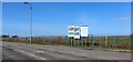
6
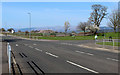
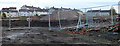
The A761 Kilmacolm Road
Arran Avenue is on the right. The pile of rubble used to be St Stephen's High School Image
Image: © Thomas Nugent
Taken: 13 Apr 2020
0.09 miles
7
A761 Kilmacolm Road
St Stephen's school fence is on the left, Bardrainney on the right.
Image: © Thomas Nugent
Taken: 6 Jan 2011
0.09 miles
8
Site of St Stephen's High School
The school was demolished after the new Port Glasgow Community Campus opened. Houses are being built here now.
See the building in 2007 Image
Image: © Thomas Nugent
Taken: 13 Apr 2020
0.10 miles
9
Former school site on Southfield Avenue
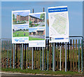
Built as Port Glasgow High School in the 1950s, transferred to St Stephen's High School in 1971, later used as a temporary decant school for the five miles distant Lady Alice Primary School in Greenock while that building was being renovated.
The site is currently being developed for housing.
Image: © Thomas Nugent
Taken: 7 Feb 2020
0.11 miles
10
Former school site on Southfield Avenue
Built as Port Glasgow High School in the 1950s, transferred to St Stephen's High School in 1971, later used as a temporary decant school for the five miles distant Lady Alice Primary School in Greenock while that building was being renovated.
The site is currently being developed for housing. Iona Road and Arran Avenue are in the distance.
Image: © Thomas Nugent
Taken: 7 Feb 2020
0.11 miles