IMAGES TAKEN NEAR TO
Mallaig Road, PORT GLASGOW, PA14 5YH
Introduction
This page details the photographs taken nearby to Mallaig Road, PA14 5YH by members of the Geograph project.
The Geograph project started in 2005 with the aim of publishing, organising and preserving representative images for every square kilometre of Great Britain, Ireland and the Isle of Man.

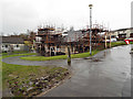
There are currently over 7.5m images from over14,400 individuals and you can help contribute to the project by visiting https://www.geograph.org.uk
Image Map (Loading...)


Getting Data...Please wait
Leaflet Map data © OpenStreetMap
Images are licensed for reuse under creativecommons.org/licenses/by-sa/2.0
Notes
- Clicking on the map will re-center to the selected point.
- The higher the marker number, the further away the image location is from the centre of the postcode.
Image Listing (92 Images Found)
Images are licensed for reuse under creativecommons.org/licenses/by-sa/2.0
Image
Details
Distance
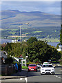
1
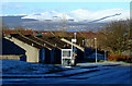
Monkton Place
The snow covered hills beyond Helensburgh provide a spectacular backdrop.
See the same scene without snow here Image
Image: © Thomas Nugent
Taken: 6 Jan 2011
0.06 miles
2
Leperstone Avenue
Off Crosshill Road at Dubbs Road.
Image: © Thomas Nugent
Taken: 13 Dec 2013
0.06 miles
3
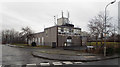
Telephone exchange
On Crosshill Place at Crosshill Road, off Dubbs Road.
This is the location of the former Upper Port Glasgow Goods station on the former Glasgow to Princes Pier railway line.
Image: © Thomas Nugent
Taken: 13 Dec 2013
0.08 miles
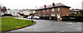
4
Monkton Place
A sheltered housing complex off Auchenbothie Road. Ben Bowie on the other side of the Clyde near Helensburgh is visible in the distance.
Image: © Thomas Nugent
Taken: 6 Jan 2011
0.08 miles
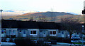
5
Monkton Place
The buildings in this sheltered housing complex are having their roofs renovated.
Image: © Thomas Nugent
Taken: 13 Dec 2013
0.08 miles
6
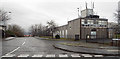
Telephone exchange
On Crosshill Place off Crosshill Road at Dubbs Road.
This is the location of the former Upper Port Glasgow Goods station on the former Glasgow to Princes Pier railway line.
Image: © Thomas Nugent
Taken: 13 Dec 2013
0.08 miles
7
Auchenbothie Road
Looking down the hill towards Dubbs Road, the distant hills are beyond Helensburgh on the north bank of the Firth of Clyde.
Image: © Thomas Nugent
Taken: 14 Sep 2017
0.09 miles
8
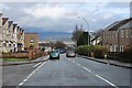
Auchenbothie Road, Bardrainney
Dropping towards the River Clyde.
Image: © Alan Reid
Taken: 19 Mar 2017
0.09 miles
9
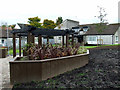
Monkton Place
Recent landscaping works at the sheltered housing complex off Auchenbothie Road.
Image: © Thomas Nugent
Taken: 20 Oct 2012
0.09 miles
10
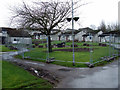
Monkton Place
A small sheltered housing complex, built in the 1970s on the site of what was known locally as the BB football pitch, by the former Greenock Princess Pier to Glasgow railway line.
Image: © Thomas Nugent
Taken: 27 Feb 2012
0.09 miles