IMAGES TAKEN NEAR TO
Auchinleck Terrace, PORT GLASGOW, PA14 5SP
Introduction
This page details the photographs taken nearby to Auchinleck Terrace, PA14 5SP by members of the Geograph project.
The Geograph project started in 2005 with the aim of publishing, organising and preserving representative images for every square kilometre of Great Britain, Ireland and the Isle of Man.

There are currently over 7.5m images from over14,400 individuals and you can help contribute to the project by visiting https://www.geograph.org.uk
Image Map
Images are licensed for reuse under creativecommons.org/licenses/by-sa/2.0
Notes
- Clicking on the map will re-center to the selected point.
- The higher the marker number, the further away the image location is from the centre of the postcode.
Image Listing (114 Images Found)
Images are licensed for reuse under creativecommons.org/licenses/by-sa/2.0
Image
Details
Distance
2
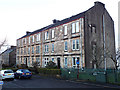
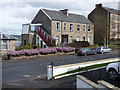
Auchinleck Terrace
Two former mill workers' tenements on Clune Brae, built to house workers from the Gourock Ropeworks mill which was located at the bottom of Clune Brae.
Image: © Thomas Nugent
Taken: 8 Oct 2022
0.01 miles
4
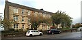
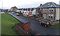
Clune Brae
The houses are on the original Clune Brae. The road in the foreground is the A761 which opened in the late 1960s and is also known as Clune Brae.
Image: © Thomas Nugent
Taken: 20 Feb 2012
0.03 miles
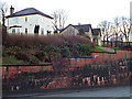
5
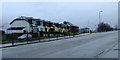
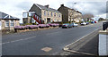
Clune Brae
The A761 Kilmacolm Road was realigned in the late 1960s. It used to run where the raised flower bed now stands.
Image: © Thomas Nugent
Taken: 8 Apr 2016
0.03 miles
6
Clune Brae
The A761 Kilmacolm Road was realigned in the late 1960s. It used to run where the raised flower bed now stands.
Image: © Thomas Nugent
Taken: 8 Apr 2016
0.03 miles
7
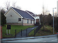
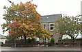
Church Of The Nazarene
On the A761 Clune Brae/Kilmacolm Road.
Image: © Thomas Nugent
Taken: 13 Dec 2013
0.03 miles
8
Clune Brae
This is the original Clune Brae road. The present road (the A761 Kilmacolm Road) can be seen to the left.
Image: © Thomas Nugent
Taken: 13 Dec 2013
0.05 miles
9
Private Road
I don't think this road, above the Clune Brae opposite High Carnegie, has a proper name.
Image: © Thomas Nugent
Taken: 13 Dec 2013
0.05 miles
10
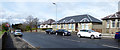
Clune Brae
Bungalows at the brow of the hill.
Image: © Thomas Nugent
Taken: 8 Apr 2016
0.06 miles