IMAGES TAKEN NEAR TO
Mt Pleasant, Barr's Brae, PORT GLASGOW, PA14 5PU
Introduction
This page details the photographs taken nearby to Mt Pleasant, Barr's Brae, PA14 5PU by members of the Geograph project.
The Geograph project started in 2005 with the aim of publishing, organising and preserving representative images for every square kilometre of Great Britain, Ireland and the Isle of Man.

There are currently over 7.5m images from over14,400 individuals and you can help contribute to the project by visiting https://www.geograph.org.uk
Image Map
Images are licensed for reuse under creativecommons.org/licenses/by-sa/2.0
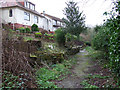
Notes
- Clicking on the map will re-center to the selected point.
- The higher the marker number, the further away the image location is from the centre of the postcode.
Image Listing (887 Images Found)
Images are licensed for reuse under creativecommons.org/licenses/by-sa/2.0
Image
Details
Distance
1
Mountpleasant
An unnamed lane between Mountpleasant and Craigard.
Image: © Thomas Nugent
Taken: 10 Mar 2012
0.01 miles
2
Hoods Well
On the west-bound platform at Port Glasgow railway station. Hood was a Station master at Port Glasgow. See also Image
Image: © Thomas Nugent
Taken: 6 Jan 2010
0.01 miles
3
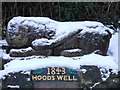
Hoods Well
On the west-bound platform at Port Glasgow railway station. Hood was a Station master at Port Glasgow. See also Image and Image
Image: © Thomas Nugent
Taken: 6 Jan 2010
0.01 miles
5
Highholm Avenue
With Glenhuntly above, to the right.
Image: © Thomas Nugent
Taken: 23 Nov 2008
0.02 miles
6
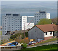
Port Glasgow and the Clyde
Looking upstream from Glenhuntly Avenue.
Image: © Thomas Nugent
Taken: 1 May 2017
0.03 miles
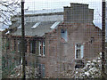
7
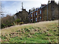
Craigard
Off Barrs Brae, viewed from the Park & Ride car park on the site of Highholm School.
Image: © Thomas Nugent
Taken: 8 Feb 2016
0.03 miles
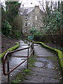
8
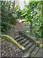
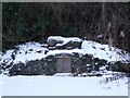
Steps off Barrs Brae
There were large houses at the lower end of Barrs Brae until the early 1970s. This is the remains of the path to one of them. The path leads to Highholm Avenue.
Image: © Thomas Nugent
Taken: 1 May 2017
0.03 miles
9
Highholm School demolition
Viewed from the lane at Mountpleasant.
Image: © Thomas Nugent
Taken: 10 Mar 2012
0.03 miles
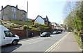
10
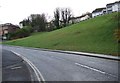
Barrs Brae
Looking down the hill to the gable end of Craigard.
Image: © Thomas Nugent
Taken: 27 Feb 2012
0.04 miles