IMAGES TAKEN NEAR TO
Kilmory Terrace, PORT GLASGOW, PA14 5PF
Introduction
This page details the photographs taken nearby to Kilmory Terrace, PA14 5PF by members of the Geograph project.
The Geograph project started in 2005 with the aim of publishing, organising and preserving representative images for every square kilometre of Great Britain, Ireland and the Isle of Man.

There are currently over 7.5m images from over14,400 individuals and you can help contribute to the project by visiting https://www.geograph.org.uk
Image Map
Images are licensed for reuse under creativecommons.org/licenses/by-sa/2.0
Notes
- Clicking on the map will re-center to the selected point.
- The higher the marker number, the further away the image location is from the centre of the postcode.
Image Listing (806 Images Found)
Images are licensed for reuse under creativecommons.org/licenses/by-sa/2.0
Image
Details
Distance
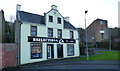
1
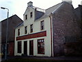
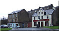
Restored building
This building on Newark Street was derelict for many years before being restored. Newark Street has all but disappeared as a result of recent road improvements associated with a new supermarket.
Image: © Thomas Nugent
Taken: 6 May 2006
0.02 miles
2
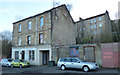
Newark Street
Number 14 to 16 Nweark Street, with Kilmory Terrace behind.
Image: © Thomas Nugent
Taken: 8 Jan 2019
0.03 miles
3
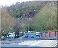
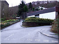
Clune Brae Foot
The foot of the A761 Clune Brae at the junction of Newark Street, which is on the right. The tenements which stood on both sides of the road were demolished in the late 1960s/early 1970s at which time the bend in the road was re-aligned and made less sharp.
This is the west end of the A761 which runs through Kilmacolm, Bridge of Weir and Paisley to end at Ibrox, where it rejoins the A8.
Image: © Thomas Nugent
Taken: 8 Jan 2019
0.03 miles
4
Newark Street
Viewed across the A761 Clune Brae.
Image: © Thomas Nugent
Taken: 8 Apr 2016
0.03 miles
5
Newark Place and Lower Bouverie Street
Newark Place is the narrow lane on the left.
Image: © Thomas Nugent
Taken: 27 Jan 2013
0.03 miles
6
Newark Street
Between Clune Brae and Bouverie Street.
Image: © Thomas Nugent
Taken: 27 Jan 2013
0.03 miles
7
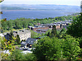
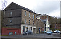
Robert Street tenements
The flat roofed, red sandstone tenements are also known as Glasgow Road tenements, soon to be demolished.
The Firth of Clyde can be seen narrowing to the plain old River Clyde in the background, with Dumbarton Rock in the right distance.
Image: © Thomas Nugent
Taken: 12 May 2016
0.03 miles
8
Reflections, Newark Street
The well maintained building is on Newark Street, dates from 1770 and is Caegory B Listed http://portal.historicenvironment.scot/designation/LB40077 .
Image: © Thomas Nugent
Taken: 8 Jan 2019
0.03 miles
9
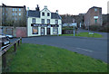
Reflections
The well maintained building is on Newark Street, dates from 1770 and is Caegory B Listed http://portal.historicenvironment.scot/designation/LB40077 .
Image: © Thomas Nugent
Taken: 8 Jan 2019
0.03 miles
10
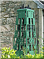
Sculpture at Newark Street
I am not sure what this represents - it appears to have a religious theme. At the corner of Newark Street and Lower Bouverie Street.
Image: © Thomas Nugent
Taken: 28 Jun 2014
0.03 miles