IMAGES TAKEN NEAR TO
Robert Street, PORT GLASGOW, PA14 5NR
Introduction
This page details the photographs taken nearby to Robert Street, PA14 5NR by members of the Geograph project.
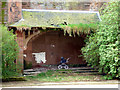
The Geograph project started in 2005 with the aim of publishing, organising and preserving representative images for every square kilometre of Great Britain, Ireland and the Isle of Man.

There are currently over 7.5m images from over14,400 individuals and you can help contribute to the project by visiting https://www.geograph.org.uk
Image Map
Images are licensed for reuse under creativecommons.org/licenses/by-sa/2.0
Notes
- Clicking on the map will re-center to the selected point.
- The higher the marker number, the further away the image location is from the centre of the postcode.
Image Listing (578 Images Found)
Images are licensed for reuse under creativecommons.org/licenses/by-sa/2.0
Image
Details
Distance
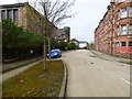
1
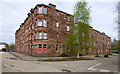
Wallace Street
Viewed from Robert Street.
Image: © Thomas Nugent
Taken: 17 Apr 2017
0.01 miles
2
Bruce Street
Looking towards Glasgow Road and the railway line.
Image: © Thomas Nugent
Taken: 17 Apr 2017
0.02 miles
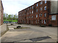
3
Robert Street Home Zone
Image: © Thomas Nugent
Taken: 6 Jun 2008
0.02 miles
4
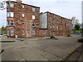
Former Clune Park Primary School
On Robert Street. Now empty and overgrown.
Image: © Thomas Nugent
Taken: 17 Apr 2017
0.02 miles
5
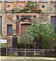
Former Clune Park Primary School
The main door is gradually disappearing behind shrubbery.
Image: © Thomas Nugent
Taken: 17 Apr 2017
0.02 miles
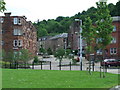
6
Robert Street
Looking west at Wallace Street.
Image: © Thomas Nugent
Taken: 17 Apr 2017
0.02 miles
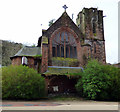
7
Clune Park Church and Clune Park School
Both on Robert Street, both Category B Listed, both disused. The church is in poor condition.
Church Listing: http://portal.historicenvironment.scot/designation/LB40072 .
School Listing: http://portal.historicenvironment.scot/designation/LB40073 .
Compare with the same view in 2009 Image
Image: © Thomas Nugent
Taken: 17 Apr 2017
0.02 miles
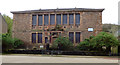
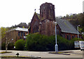
8
Former Clune Park Church
Slowly rotting away on Robert Street. Category B Listed http://portal.historicenvironment.scot/designation/LB40072 .
See also Image
Image: © Thomas Nugent
Taken: 17 Apr 2017
0.03 miles
9
Former Clune Park Church
Slowly rotting away on Robert Street. Category B Listed http://portal.historicenvironment.scot/designation/LB40072 .
See also Image
Image: © Thomas Nugent
Taken: 17 Apr 2017
0.03 miles
10
Bruce Street
Viewed from Robert Street.
Image: © Thomas Nugent
Taken: 17 Apr 2017
0.03 miles