IMAGES TAKEN NEAR TO
Alderbrae Road, PORT GLASGOW, PA14 5LW
Introduction
This page details the photographs taken nearby to Alderbrae Road, PA14 5LW by members of the Geograph project.
The Geograph project started in 2005 with the aim of publishing, organising and preserving representative images for every square kilometre of Great Britain, Ireland and the Isle of Man.

There are currently over 7.5m images from over14,400 individuals and you can help contribute to the project by visiting https://www.geograph.org.uk
Image Map (Loading...)


Getting Data...Please wait
Leaflet Map data © OpenStreetMap
Images are licensed for reuse under creativecommons.org/licenses/by-sa/2.0
Notes
- Clicking on the map will re-center to the selected point.
- The higher the marker number, the further away the image location is from the centre of the postcode.
Image Listing (177 Images Found)
Images are licensed for reuse under creativecommons.org/licenses/by-sa/2.0
Image
Details
Distance
1
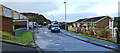
Alderbrae Road
At Alderwood Crescent, which is on the left.
Image: © Thomas Nugent
Taken: 8 Feb 2016
0.01 miles
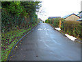
2
Alderwood Crescent
Looking down the hill towards Alderwood Road.
Image: © Thomas Nugent
Taken: 8 Feb 2016
0.04 miles
3
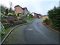
Alderwood Crescent
Looking up the hill from Alderwood Road.
Image: © Thomas Nugent
Taken: 8 Feb 2016
0.04 miles
4
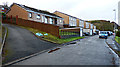
Alderbrae Road
At the top of Alderwood Road. Alderwood Crescent is on the left.
Image: © Thomas Nugent
Taken: 8 Feb 2016
0.04 miles
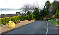
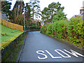
5
Alderbrae Road
In the west end of Port Glasgow, viewed from National Cycle Network Route 75 in Devol Glen.
Image: © Thomas Nugent
Taken: 23 Nov 2009
0.04 miles
6
Alderwood Road
Looking up the hill from Bogiewood Road. Note the sandbags on the right to divert excess surface water from recent heavy rainfall.
Image: © Thomas Nugent
Taken: 8 Feb 2016
0.06 miles
7
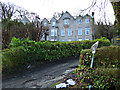
Alderwood House
Near the top of Alderwood Road.
Image: © Thomas Nugent
Taken: 8 Feb 2016
0.06 miles
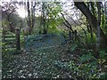
8
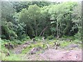
Clearing, Devol Glen
As there is no longer a viaduct over the Devol Glen, the cycle path (NCN route 75) has to leave the trackbed of the Greenock and Ayrshire railway and descend steeply into the gorge.
An area of woodland has been cleared away on the side of the deep cleuch carrying the Devol Burn from the plateau to the Clyde.
Image: © Richard Webb
Taken: 22 Jun 2009
0.06 miles
9
Alderwood Road
Looking down the hill from the entrance to Bogiewoode.
Image: © Thomas Nugent
Taken: 8 Feb 2016
0.06 miles
10
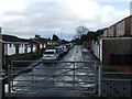
Gate beside the cycle route
The picture was taken from the cycle route. This gate is on its uphill (southern) side. On the other side of the gate, a track leads off to the right; it follows a circuitous route for about 1.3 km, to meet Dougliehill Road at Image, at the gate shown in Image
From a matching gate on the other side of the road (Image), the track continues for another 700 metres, the entire 2 km route ending at Image, near the clubhouse of Image
There are some footpaths signposted from there (Image), but, as far as I know, they do not include the track just described (one that may not be intended for public use).
Image: © Lairich Rig
Taken: 24 Oct 2016
0.06 miles