IMAGES TAKEN NEAR TO
Alderwood Road, PORT GLASGOW, PA14 5LE
Introduction
This page details the photographs taken nearby to Alderwood Road, PA14 5LE by members of the Geograph project.
The Geograph project started in 2005 with the aim of publishing, organising and preserving representative images for every square kilometre of Great Britain, Ireland and the Isle of Man.

There are currently over 7.5m images from over14,400 individuals and you can help contribute to the project by visiting https://www.geograph.org.uk
Image Map
Images are licensed for reuse under creativecommons.org/licenses/by-sa/2.0
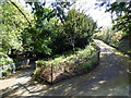
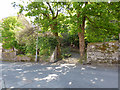
Notes
- Clicking on the map will re-center to the selected point.
- The higher the marker number, the further away the image location is from the centre of the postcode.
Image Listing (684 Images Found)
Images are licensed for reuse under creativecommons.org/licenses/by-sa/2.0
Image
Details
Distance
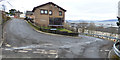
1
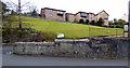
Alderwood Road
Viewed from Glen Avenue.
Image: © Thomas Nugent
Taken: 26 Feb 2018
0.02 miles
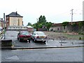
2
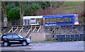
Subsidence at Glen Avenue
The struts are in the grounds of the former Jean Street School, now known as School Court.
Image: © Thomas Nugent
Taken: 6 Jan 2011
0.03 miles
3
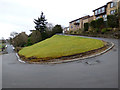
Alderwood Road
One of the hairpin bends at the lower part of the road.
Image: © Thomas Nugent
Taken: 26 Feb 2018
0.03 miles
4
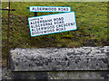
Road signs at Alderwood Road
Leading to Alderbank Road, Alderbrae Road, Alderwood Crescent and Bogiewood Road. At the junction with Glen Avenue.
Image: © Thomas Nugent
Taken: 26 Feb 2018
0.03 miles
5
Alderwood Road
One of the hairpin bends at the lower part of the road.
Image: © Thomas Nugent
Taken: 26 Feb 2018
0.03 miles
6
Site of former Army barracks
A Territotial Army base stood here, amongst the Highholm Street tenements. The Glasgow-Gourock & Wemyss Bay railway line is to the right. A block of flats now stands here Image
Image: © Thomas Nugent
Taken: 30 Jun 2007
0.03 miles
7
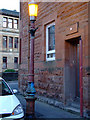
Provost's lamp
A fancy lamp was situated on the street outside the home of the serving provost. The original lamp was more ornate than the existing one as can be seen outside the Town Buildings Image
See also Image
Image: © Thomas Nugent
Taken: 6 Jan 2011
0.03 miles
8
Driveway to Birkmyre Park
Off Glen Avenue at Alderwood Road. Early maps show this is the driveway of the former West Glenhuntly house http://maps.nls.uk/view/74966013#zoom=4&lat=5716&lon=11157&layers=BT . It must have been a challenge to take a horse and carriage up or down this steep, winding gradient.
Image: © Thomas Nugent
Taken: 1 May 2017
0.04 miles
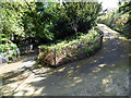
9
Driveway to Birkmyre Park
Off Glen Avenue at Alderwood Road. Early maps show this is the driveway of the former West Glenhuntly house http://maps.nls.uk/view/74966013#zoom=4&lat=5716&lon=11157&layers=BT . It must have been a challeng to take a horse and carriage up or down this steep, winding gradient.
Image: © Thomas Nugent
Taken: 1 May 2017
0.04 miles
10
Entrance to Birkmyre Park
On Glen Avenue at Alderwood Road. Early maps show this is the entrance to the driveway of the former West Glenhuntly house http://maps.nls.uk/view/74966013#zoom=4&lat=5716&lon=11157&layers=BT .
Image: © Thomas Nugent
Taken: 1 May 2017
0.04 miles