IMAGES TAKEN NEAR TO
Glenpark Drive, PORT GLASGOW, PA14 5AJ
Introduction
This page details the photographs taken nearby to Glenpark Drive, PA14 5AJ by members of the Geograph project.
The Geograph project started in 2005 with the aim of publishing, organising and preserving representative images for every square kilometre of Great Britain, Ireland and the Isle of Man.

There are currently over 7.5m images from over14,400 individuals and you can help contribute to the project by visiting https://www.geograph.org.uk
Image Map
Images are licensed for reuse under creativecommons.org/licenses/by-sa/2.0
Notes
- Clicking on the map will re-center to the selected point.
- The higher the marker number, the further away the image location is from the centre of the postcode.
Image Listing (387 Images Found)
Images are licensed for reuse under creativecommons.org/licenses/by-sa/2.0
Image
Details
Distance
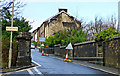
1
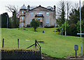
Glenpark House
It could almost be mistaken for a country house in this view from Glenburn Street if it wasn't for the street lights. A Category C Listed building http://portal.historic-scotland.gov.uk/hes/web/f?p=PORTAL:DESIGNATION:::::DES:LB46409 .
Image: © Thomas Nugent
Taken: 8 Feb 2016
0.00 miles
2
Glenpark House
The original section of the Category C Listed building http://portal.historic-scotland.gov.uk/hes/web/f?p=PORTAL:DESIGNATION:::::DES:LB46409 is on the right. The larger rear section was a later addition.
Image: © Thomas Nugent
Taken: 8 Feb 2016
0.00 miles
3
Glenpark Drive
Looking down the hill towards the new housing developments at Kingston Dock.
Image: © Thomas Nugent
Taken: 8 Feb 2016
0.02 miles
4
Glenpark House
Viewed from Glenburn Street.
Image: © Thomas Nugent
Taken: 8 Feb 2016
0.03 miles
5
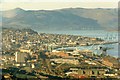
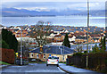
Greenock from Dougliehill
A scanned photograph, taken around 1986. Much has changed since then...
The large twin roofed shed to the left of the Titan crane was Scott's shipyard; MacDonalds, Misco, a T-Mobile Call Centre and the RBS Mortgage Centre now stand there.
To the left of Scott's, the large red brick building was John G Kincaid's marine engine works where they made engines bigger than a house.
The "Wee Dublin End" terracing at Morton's Cappielow Park can be seen just below Kincaid's.
There are two old school buildings in the right foreground, the nearest (Ladyburn Primary) is now part of Riverside Business Park, the one immediately behind it was St Mungo's RC Primary, now demolished.
All of the sheds in the centre are also gone, replaced by the Waterfront Leisure Centre.
Greenock Container Terminal (now Greenock Ocean Terminal) with its distinctive cranes is to the right.
The Glasgow to Gourock railway line and the James Watt Dock line to its right can also be seen.
Strone Point and Strone Hill are prominent in the distance, across the Firth of Clyde.
Image: © Thomas Nugent
Taken: Unknown
0.03 miles
6
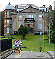
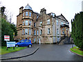
Glenpark House
The two distinct phases of the Category C Listed building http://portal.historic-scotland.gov.uk/hes/web/f?p=PORTAL:DESIGNATION:::::DES:LB46409 can be appreciated from this viewpoint in Glenburn Road.
Historic Scotland described it as follows, "As shown on the 1856 OS map, Glenpark was originally a simple rectangular-plan, 3-bay classical villa with a stair accessing an entrance centred in the front elevation. Subsequently enlarged and dwarfed by the later work, this original structure remains essentially intact - the giant order pilasters and finialled pediment being particularly good. The addition, itself well-detailed, is particularly notable for its polygonal tower. Although quirky, the juxtaposition of the two parts of Glenpark House is of interest, with elements working to tie them together to achieve an imaginative composition.".
Image: © Thomas Nugent
Taken: 8 Feb 2016
0.04 miles
7
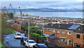
Glenpark Drive
Looking down on Glenpark Drive and the new housing developments at Kingston Dock from Ivybank Crescent.
Image: © Thomas Nugent
Taken: 8 Feb 2016
0.05 miles
8
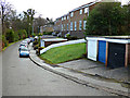
Rossbank Road
Off Glenpark Drive, overlooking Glen Avenue.
Image: © Thomas Nugent
Taken: 8 Feb 2016
0.05 miles
9
Lilybank Road
The east end of the road at the bridge over the Glen Burn.
Image: © Thomas Nugent
Taken: 8 Feb 2016
0.05 miles
10
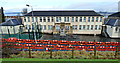
St John's RC Primary School
Recently extensively renovated.
Image: © Thomas Nugent
Taken: 8 Feb 2016
0.05 miles