IMAGES TAKEN NEAR TO
Regent Street, PAISLEY, PA1 3TG
Introduction
This page details the photographs taken nearby to Regent Street, PA1 3TG by members of the Geograph project.
The Geograph project started in 2005 with the aim of publishing, organising and preserving representative images for every square kilometre of Great Britain, Ireland and the Isle of Man.

There are currently over 7.5m images from over14,400 individuals and you can help contribute to the project by visiting https://www.geograph.org.uk
Image Map
Images are licensed for reuse under creativecommons.org/licenses/by-sa/2.0
Notes
- Clicking on the map will re-center to the selected point.
- The higher the marker number, the further away the image location is from the centre of the postcode.
Image Listing (89 Images Found)
Images are licensed for reuse under creativecommons.org/licenses/by-sa/2.0
Image
Details
Distance
1
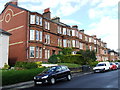
Regent Street
Red sandstone block of flats with front gardens.
Image: © Thomas Nugent
Taken: 7 May 2007
0.01 miles
2

Whitehaugh Avenue
North of the Kelburne Oval junction.
Image: © Thomas Nugent
Taken: 5 May 2014
0.06 miles
3
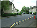
Whitehaugh Avenue
North of the Kelburne Oval junction.
Image: © Thomas Nugent
Taken: 5 May 2014
0.07 miles
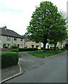
5

Whitehaugh Avenue
Houses in a lane off Whitehaugh Avenue.
Image: © Thomas Nugent
Taken: 5 May 2014
0.08 miles
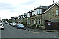
6
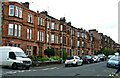
Whitehaugh Drive
Red sandstone tenements on the west side of the road.
Image: © Thomas Nugent
Taken: 5 May 2014
0.09 miles
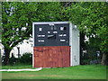
7
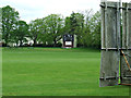
Kelburne Cricket Club
Scoreboard and screen at the east side of the ground.
Image: © Thomas Nugent
Taken: 5 May 2014
0.10 miles
9

Former Whitehaugh Barracks
The Kelburne Oval side of the building.
Image: © Thomas Nugent
Taken: 5 May 2014
0.11 miles
10
Kelburne Drive
Off Whitehaugh Avenue.
Image: © Thomas Nugent
Taken: 5 May 2014
0.12 miles