IMAGES TAKEN NEAR TO
West Glen Road, KILMACOLM, PA13 4PN
Introduction
This page details the photographs taken nearby to West Glen Road, PA13 4PN by members of the Geograph project.
The Geograph project started in 2005 with the aim of publishing, organising and preserving representative images for every square kilometre of Great Britain, Ireland and the Isle of Man.

There are currently over 7.5m images from over14,400 individuals and you can help contribute to the project by visiting https://www.geograph.org.uk
Image Map
Images are licensed for reuse under creativecommons.org/licenses/by-sa/2.0
Notes
- Clicking on the map will re-center to the selected point.
- The higher the marker number, the further away the image location is from the centre of the postcode.
Image Listing (18 Images Found)
Images are licensed for reuse under creativecommons.org/licenses/by-sa/2.0
Image
Details
Distance
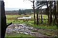
1
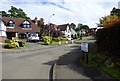
Lodge Park
A housing estate off West Glen Road.
Image: © Thomas Nugent
Taken: 14 Sep 2017
0.11 miles
2
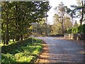
Kilmacolm
Coming in from West Glen Road.
Image: © william craig
Taken: 27 Oct 2005
0.13 miles
5
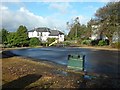
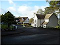
Playpark in Kilmacolm
At West Glen Road and Finlaystone Road.
Image: © Stephen Sweeney
Taken: 20 Sep 2011
0.20 miles
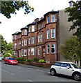
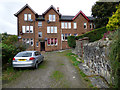
6
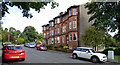
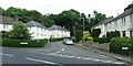
Tenement on West Glen Road
A red sandstone tenement overlooking the park on West Glen Road.
Image: © Thomas Nugent
Taken: 14 Sep 2017
0.22 miles
7
Tenement on West Glen Road
A red sandstone tenement overlooking the park on West Glen Road.
Image: © Thomas Nugent
Taken: 14 Sep 2017
0.22 miles
9
Glenburn Place
Image: © Thomas Nugent
Taken: 14 Sep 2017
0.23 miles
10
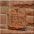
Glenburn Place
Image: © Thomas Nugent
Taken: 14 Sep 2017
0.23 miles