IMAGES TAKEN NEAR TO
Glenmosston Road, KILMACOLM, PA13 4PF
Introduction
This page details the photographs taken nearby to Glenmosston Road, PA13 4PF by members of the Geograph project.
The Geograph project started in 2005 with the aim of publishing, organising and preserving representative images for every square kilometre of Great Britain, Ireland and the Isle of Man.

There are currently over 7.5m images from over14,400 individuals and you can help contribute to the project by visiting https://www.geograph.org.uk
Image Map
Images are licensed for reuse under creativecommons.org/licenses/by-sa/2.0
Notes
- Clicking on the map will re-center to the selected point.
- The higher the marker number, the further away the image location is from the centre of the postcode.
Image Listing (8 Images Found)
Images are licensed for reuse under creativecommons.org/licenses/by-sa/2.0
Image
Details
Distance
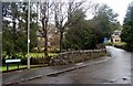
1
Path, Glen Moss
Passing trees growing from a garden.
Image: © Richard Webb
Taken: 19 Apr 2013
0.14 miles
2
Windy Hill
Image: © Thomas Nugent
Taken: 1 Mar 2007
0.15 miles
3
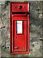
VR postbox
On Barclaven Road, Kilmacolm.
Image: © Thomas Nugent
Taken: 1 Mar 2007
0.17 miles

6
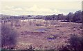
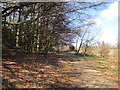
Glen Moss, Kilmacolm
Scottish Wildlife Trust reserve.
Image: © Richard Sutcliffe
Taken: Unknown
0.20 miles
7
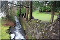
Gill Burn
Partially culverted, the burn eventually reaches the Gryfe Water.
Image: © Alan Reid
Taken: 19 Mar 2017
0.21 miles