IMAGES TAKEN NEAR TO
Bridge Of Weir Road, KILMACOLM, PA13 4NN
Introduction
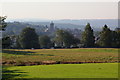
This page details the photographs taken nearby to Bridge Of Weir Road, PA13 4NN by members of the Geograph project.
The Geograph project started in 2005 with the aim of publishing, organising and preserving representative images for every square kilometre of Great Britain, Ireland and the Isle of Man.

There are currently over 7.5m images from over14,400 individuals and you can help contribute to the project by visiting https://www.geograph.org.uk
Image Map
Images are licensed for reuse under creativecommons.org/licenses/by-sa/2.0
Notes
- Clicking on the map will re-center to the selected point.
- The higher the marker number, the further away the image location is from the centre of the postcode.
Image Listing (128 Images Found)
Images are licensed for reuse under creativecommons.org/licenses/by-sa/2.0
Image
Details
Distance
1
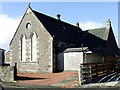
Kilmacolm Masonic Temple
In a former church on Glebe Road.
Image: © Thomas Nugent
Taken: 1 Mar 2007
0.10 miles
2
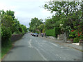
Gryffe Road
Looking towards Lochwinnoch Road in the centre of the village.
Image: © Thomas Nugent
Taken: 14 Jun 2013
0.10 miles
3
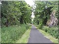
Greenock and Ayrshire Railway, Kilmacolm
Approaching the site of Kilmacolm Station through a cutting. The railway to Greenock was closed in 1966, but a service to Glasgow via Paisley Canal continued from Kilmacolm until 1983 when it fell to what appeared at the time to be another round of savage railway closures. There is pressure for reopening, at least from Bridge of Weir. Now the trackbed is a cycle path.
Image: © Richard Webb
Taken: 22 Jun 2009
0.10 miles
4
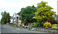
Gryffe Road
St Columba's Senior School http://www.st-columbas.org/page/Home.aspx , at the junction with Lyle Road.
St Columba's was one of the first schools to make use of the geograph archive.
Image: © Thomas Nugent
Taken: 14 Jun 2013
0.10 miles
5
Former Kilmacolm Public School
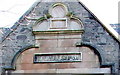
Note the unusual spelling of 'Kilmalcolm', which predates 1905 when the name of the village was changed to the present day 'Kilmacolm'.
See also Image
Image: © Thomas Nugent
Taken: 1 Mar 2007
0.12 miles
6
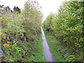
The cycle path on the track bed of the old Greenock and Ayrshire Railway at Kilmacolm
Image: © Elliott Simpson
Taken: 18 May 2012
0.13 miles
7
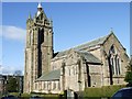
St Columba's Church
An imposing building on Duchal Road. See also Image
Image: © Thomas Nugent
Taken: 1 Mar 2007
0.14 miles
8
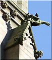
Gargoyle
Complete with live crow - on St Columba's Church Image
Image: © Thomas Nugent
Taken: 1 Mar 2007
0.14 miles
9
St Columba Church Of Scotland
Photo taken from the field next to Kilmacolm cemetery main road off Port Glasgow Road.
Image: © david cameron photographer
Taken: 11 Sep 2015
0.14 miles
10
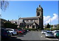
St Columba Church of Scotland, Kilmacolm
Church of Scotland Category A listed church http://portal.historicenvironment.scot/designation/LB12448 dating from 1902. It was formerly the United Presbyterian St James's Church.
Image: © Richard Sutcliffe
Taken: 27 Apr 2024
0.14 miles