IMAGES TAKEN NEAR TO
Gryffe Road, KILMACOLM, PA13 4BA
Introduction
This page details the photographs taken nearby to Gryffe Road, PA13 4BA by members of the Geograph project.
The Geograph project started in 2005 with the aim of publishing, organising and preserving representative images for every square kilometre of Great Britain, Ireland and the Isle of Man.

There are currently over 7.5m images from over14,400 individuals and you can help contribute to the project by visiting https://www.geograph.org.uk
Image Map
Images are licensed for reuse under creativecommons.org/licenses/by-sa/2.0
Notes
- Clicking on the map will re-center to the selected point.
- The higher the marker number, the further away the image location is from the centre of the postcode.
Image Listing (11 Images Found)
Images are licensed for reuse under creativecommons.org/licenses/by-sa/2.0
Image
Details
Distance
1
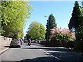
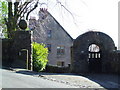
A761, Bridge of Weir Road, Kilmacolm
Image: © Elliott Simpson
Taken: 14 May 2016
0.06 miles
2
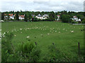
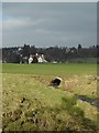
Field in Kilmacolm
Sheep grazing between Gryffe Road and the cycle path.
Image: © Thomas Nugent
Taken: 14 Jun 2013
0.07 miles
3
Porterfield Road
Road leading to Golf Course
Image: © william craig
Taken: 21 Nov 2005
0.07 miles
4
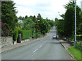
Gryffe Road
Looking towards Bridge of Weir Road.
Image: © Thomas Nugent
Taken: 14 Jun 2013
0.14 miles
6
Kilmacolm from the B788
Looking roughly north.
Image: © Stephen Sweeney
Taken: 12 Mar 2014
0.17 miles
7
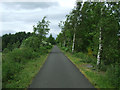
National Cycle Network Route 75
Approaching Kilmacolm from Knapps Loch.
Image: © Thomas Nugent
Taken: 14 Jun 2013
0.18 miles
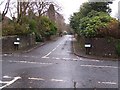
8
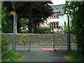
National Cycle Network Route 75
The access point at Gryffe Road.
Image: © Thomas Nugent
Taken: 14 Jun 2013
0.19 miles
9
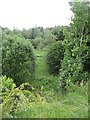
Wet woodland
Woods and marshland beside the Gryffe Water. View from the old railway to Kilmacolm (Greenock and Ayrshire).
Image: © Richard Webb
Taken: 22 Jun 2009
0.21 miles
10
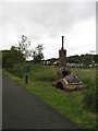
"How faur tae Glesgae?" - 18
One mile on from the Roman Army, Image, another milepost (non Sustrans), together with a locomotive constructed from the lum of a platelayer's trackside hut.
Image: © Richard Webb
Taken: 22 Jun 2009
0.24 miles