IMAGES TAKEN NEAR TO
John Neilson Avenue, PAISLEY, PA1 2SX
Introduction
This page details the photographs taken nearby to John Neilson Avenue, PA1 2SX by members of the Geograph project.
The Geograph project started in 2005 with the aim of publishing, organising and preserving representative images for every square kilometre of Great Britain, Ireland and the Isle of Man.

There are currently over 7.5m images from over14,400 individuals and you can help contribute to the project by visiting https://www.geograph.org.uk
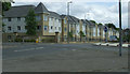
Image Map
Images are licensed for reuse under creativecommons.org/licenses/by-sa/2.0
Notes
- Clicking on the map will re-center to the selected point.
- The higher the marker number, the further away the image location is from the centre of the postcode.
Image Listing (62 Images Found)
Images are licensed for reuse under creativecommons.org/licenses/by-sa/2.0
Image
Details
Distance
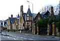
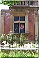
1
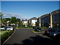
John Neilson Avenue
Private housing development on the site of John Neilson High School.
Image: © Gordon Dowie
Taken: 24 May 2010
0.02 miles
2
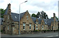
Former stable block
A Category C Listed building http://data.historic-scotland.gov.uk/pls/htmldb/f?p=2200:15:0::::BUILDING:39123 on Ferguslie.
Image: © Thomas Nugent
Taken: 14 Jun 2013
0.07 miles
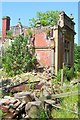
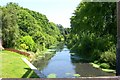
3
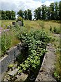
Remains of steps
The stairs are at the southern corner of an Image, and they seem to have led into it.
Image: © Lairich Rig
Taken: 7 Jul 2014
0.07 miles
4
Enclosed space near Ferguslie Gardens
To the left of the wall, the railway line is at the bottom of the slope.
When the first-edition OS map was surveyed, in 1858, this wall had not yet been built, but there was a walled garden not far ahead, part of the estate associated with the now-gone Ferguslie House. At that time, there was railway junction (Linnwood Junction) near here.
When the second edition of the map was surveyed, in about 1895, the junction was gone (there was a single line, as at present), but the wall of the enclosure shown here had been built. At the southern corner (the one from which the picture was taken), there are remains of stairs leading down into it: Image The area enclosed by this wall was probably another part of the gardens associated with Ferguslie House.
Image: © Lairich Rig
Taken: 7 Jul 2014
0.08 miles
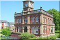
5
Scots Baronial style building on Ferguslie
The Ferguslie side of the square building which has a courtyard in the middle.
Image: © Thomas Nugent
Taken: 7 Feb 2011
0.09 miles
6
Ferguslie
Flats on the site of John Neilson High School.
Image: © Thomas Nugent
Taken: 14 Jun 2013
0.09 miles
7
Ferguslie Thread Mills, Paisley, Scotland
Bridge Lane Gate House, now converted to residential flats
Image: © Robert Sweeney
Taken: 10 Jul 2005
0.09 miles
8
Ferguslie Thread Mills, Paisley, Scotland
"Half-timers" School House
The School building was opened by Peter Coats Jnr. in January 1887. The young female workers would attend this school and work in the mills on alternate days, hence the term "Half-Timers"
Image: © Robert Sweeney
Taken: 10 Jul 2005
0.09 miles
9
Ferguslie Thread Mills, Paisley, Scotland
Ferguslie Half-time school at Maxwelton now stands derelict. Gutted by fire and further destroyed by gale-force winds.
Image: © Robert Sweeney
Taken: 10 Jul 2005
0.09 miles
10
Ferguslie Thread mills, Paisley, Scotland
View from rear of Gatehouse
Image: © Robert Sweeney
Taken: 10 Jul 2005
0.09 miles