IMAGES TAKEN NEAR TO
Brown Street, PAISLEY, PA1 2SN
Introduction
This page details the photographs taken nearby to Brown Street, PA1 2SN by members of the Geograph project.
The Geograph project started in 2005 with the aim of publishing, organising and preserving representative images for every square kilometre of Great Britain, Ireland and the Isle of Man.

There are currently over 7.5m images from over14,400 individuals and you can help contribute to the project by visiting https://www.geograph.org.uk
Image Map
Images are licensed for reuse under creativecommons.org/licenses/by-sa/2.0
Notes
- Clicking on the map will re-center to the selected point.
- The higher the marker number, the further away the image location is from the centre of the postcode.
Image Listing (413 Images Found)
Images are licensed for reuse under creativecommons.org/licenses/by-sa/2.0
Image
Details
Distance
1
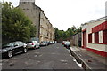
Kerr Street, Paisley
From the junction with Underwood Road.
Image: © Billy McCrorie
Taken: 21 Aug 2013
0.08 miles
2
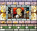
Stained Glass - William Herschel
Photographed from inside the Coats Observatory, this detail from a stained glass window depicts Sir Frederick William Herschel, a German-born astronomer who spent most of his life in Britain. He is best remembered for his discovery of the planet Uranus; however, he made many other scientific discoveries, and was also an accomplished musician.
Image: © Lairich Rig
Taken: 2 Sep 2005
0.08 miles
3
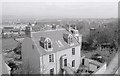
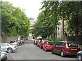
42-44 Oakshaw Street, Paisley
Category B listed dwelling [http://portal.historicenvironment.scot/designation/LB39084], dating from circa 1830. Seen from the Coats Observatory.
Image: © Richard Sutcliffe
Taken: Unknown
0.09 miles
4
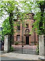
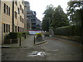
Peter Brough District Nursing Home
On Oakshaw Street. Peter Brough was a local industrialist. See the detail above the main door here Image
Image: © Thomas Nugent
Taken: 19 May 2008
0.09 miles
5
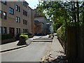
Underwood Road, Paisley
From the junction at Kerr Street.
Image: © Billy McCrorie
Taken: 21 Aug 2013
0.09 miles
6
Oakshaw Street
There are many grand buildings along Oakshaw Street which runs along high ground in the centre of Paisley. View along towards the Coates Observatory from outside the John Neilson Institute.
Image: © Richard Webb
Taken: 16 Jun 2009
0.09 miles
7

Oakshaw Street East
Looking towards Coats Observatory, the done of which can be seen on the left.
Image: © Thomas Nugent
Taken: 24 Nov 2014
0.09 miles
8
Oakshaw Street
There is a barrier in the road here; Oakshaw Street East is on this side, and Oakshaw Street West on the other. The passage from one to the other is not for regular traffic: the words "Fire Path — No Parking" appear on plaques on either side of the barrier.
The Image is in the background.
Image: © Lairich Rig
Taken: 7 Jul 2018
0.09 miles
9
West end of Oakshaw Street East, Paisley
Separated from Oakshaw Street West for vehicular traffic except fire engines.
Image: © Richard Vince
Taken: 12 Sep 2022
0.09 miles
10
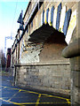
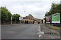
Underwood Road railway arch
This scarred old arch has seen a few clashes in its time. It carries the Glasgow to Gourock & Wemyss Bay line between Paisley Gilmour Street and Paisley St James stations.
Image: © Thomas Nugent
Taken: 7 Feb 2011
0.09 miles