IMAGES TAKEN NEAR TO
Brown Street, PAISLEY, PA1 2JE
Introduction
This page details the photographs taken nearby to Brown Street, PA1 2JE by members of the Geograph project.
The Geograph project started in 2005 with the aim of publishing, organising and preserving representative images for every square kilometre of Great Britain, Ireland and the Isle of Man.

There are currently over 7.5m images from over14,400 individuals and you can help contribute to the project by visiting https://www.geograph.org.uk
Image Map
Images are licensed for reuse under creativecommons.org/licenses/by-sa/2.0
Notes
- Clicking on the map will re-center to the selected point.
- The higher the marker number, the further away the image location is from the centre of the postcode.
Image Listing (301 Images Found)
Images are licensed for reuse under creativecommons.org/licenses/by-sa/2.0
Image
Details
Distance
1
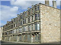
Sutherland Street
Boarded up tenements line both sides of this street.
Image: © Thomas Nugent
Taken: 31 Mar 2008
0.05 miles
2
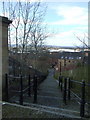
Cobbled lane
Looking down hill from Oakshawhead to Underwood Lane.
Image: © Thomas Nugent
Taken: 31 Mar 2008
0.08 miles
3
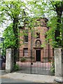
Peter Brough District Nursing Home
On Oakshaw Street. Peter Brough was a local industrialist. See the detail above the main door here Image
Image: © Thomas Nugent
Taken: 19 May 2008
0.09 miles
4
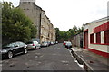
Kerr Street, Paisley
From the junction with Underwood Road.
Image: © Billy McCrorie
Taken: 21 Aug 2013
0.09 miles
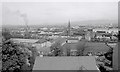
5
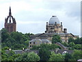
Paisley skyline
Coats church tower Image and the John Neilson Institute Image] seen from St James's railway station.
Image: © Thomas Nugent
Taken: 19 Jul 2008
0.10 miles
6
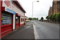
Underwood Road, Paisley
From the junction with Kerr Street.
Image: © Billy McCrorie
Taken: 21 Aug 2013
0.10 miles
7
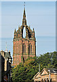
Coats Church tower
As seen from Paisley Cross.
See also Image
Image: © Thomas Nugent
Taken: 14 Sep 2015
0.11 miles
8
John Neilson Institution Oakshaw
Photo taken from the bottom of the hill in Underwood Lane off Well Street of the long demolished Old school grounds that sat under this hill top landmark building with its lead dome.
John Neilson Institution http://www.paisley.org.uk/paisley-history/john-neilson-institution/
John Neilson Institution friends reunited page : http://www.friendsreunited.co.uk/john-neilson-institution/b/e98fa565-9d87-4aca-b058-14186a8f1fcc
Image: © david cameron photographer
Taken: 1 Nov 2012
0.11 miles
9
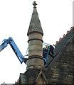
St James Church
A man at work on the roof of the Category B Listed building http://data.historic-scotland.gov.uk/pls/htmldb/f?p=2200:15:0::::BUILDING:39125 on Underwood Road.
Image: © Thomas Nugent
Taken: 14 Jun 2013
0.11 miles
10
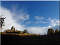
St James' Church of Scotland, Underwood Road, Paisley
Looking over the north of Paisley from the Coats Observatory.
Image: © Richard Sutcliffe
Taken: Unknown
0.11 miles