IMAGES TAKEN NEAR TO
Wellmeadow Street, PAISLEY, PA1 2EF
Introduction
This page details the photographs taken nearby to Wellmeadow Street, PA1 2EF by members of the Geograph project.
The Geograph project started in 2005 with the aim of publishing, organising and preserving representative images for every square kilometre of Great Britain, Ireland and the Isle of Man.

There are currently over 7.5m images from over14,400 individuals and you can help contribute to the project by visiting https://www.geograph.org.uk
Image Map
Images are licensed for reuse under creativecommons.org/licenses/by-sa/2.0
Notes
- Clicking on the map will re-center to the selected point.
- The higher the marker number, the further away the image location is from the centre of the postcode.
Image Listing (296 Images Found)
Images are licensed for reuse under creativecommons.org/licenses/by-sa/2.0
Image
Details
Distance
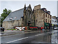
1
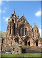
Coats Memorial Church
The Thomas Coats Memorial Church dominates the Paisley sky-line. Also known as the Baptist Cathedral Of Europe.
http://www.fenet.co.uk/coats/
Image: © Finlay Tindall
Taken: 9 Sep 2006
0.00 miles
2
Starlight Studio
Former Mission Hall on Wellmeadow Street, Paisley. Now operating as Starlight Studio.
Starlight is a theatre company established in 2002 for young people aged between 3 and 19 years. Classes are available for theatre and dance and also fitness Zumba classes for adults.
Image: © Richard Sutcliffe
Taken: 17 Sep 2019
0.01 miles
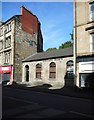
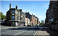
3

Wellmeadow Street
Recent demolition work has revealed the east side of this former church which was most recently Myles Camping Centre.
Image: © Thomas Nugent
Taken: 9 Feb 2009
0.02 miles
4
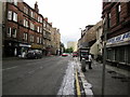
Wellmeadow Street, Paisley
From the junction at Walker Street going towards High Street.
Image: © Billy McCrorie
Taken: 14 Aug 2012
0.02 miles
5

Former church
On Wellmeadow Street, most recently used as Myles Camping Centre. See also Image
Image: © Thomas Nugent
Taken: 9 Feb 2009
0.02 miles
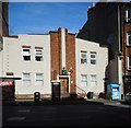
6
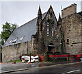
Former Original Secession Church
On Wellmeadow Street, by local architect TG Abercrombie http://www.scottisharchitects.org.uk/architect_full.php?id=100003 . I remember this being Myles Camping and Cycling Centre in the mid 1970s.
Registered as at risk on the BBAR web site which describes it as follows - "Gothic 19th century church. Paired lancet windows to front gable. Leaded windows with coloured glass. Ground floor approached on bridge over basement entrance. Slate roof. Simple, rectangular plan. Appears on the 1st edition (1:2;500 series) OS map as OS Church.
11 August 2017: Local planners advise the property is intended to form makers space and re-use/ repair works are likely to commence shortly. The interior is advised to be in good condition. Some external repairs are required to the exterior - these are intended to be completed as the property is brought back into use, Condition moved to Good and Risk to Low".
See also Image
Image: © Thomas Nugent
Taken: 4 Sep 2017
0.03 miles
7
Former Original Secession Church
On Wellmeadow Street, by local architect TG Abercrombie http://www.scottisharchitects.org.uk/architect_full.php?id=100003 . I remember this being Myles Camping and Cycling Centre in the mid 1970s.
Registered as at risk on the BBAR web site which describes it as follows - "Gothic 19th century church. Paired lancet windows to front gable. Leaded windows with coloured glass. Ground floor approached on bridge over basement entrance. Slate roof. Simple, rectangular plan. Appears on the 1st edition (1:2;500 series) OS map as OS Church.
11 August 2017: Local planners advise the property is intended to form makers space and re-use/ repair works are likely to commence shortly. The interior is advised to be in good condition. Some external repairs are required to the exterior - these are intended to be completed as the property is brought back into use, Condition moved to Good and Risk to Low".
See the same view in 2009 Image
See also Image
Image: © Thomas Nugent
Taken: 4 Sep 2017
0.03 miles
8
Wellmeadow Street, Paisley
The building in the centre is Paisley muslim community trust Paisley mosque https://www.geograph.org.uk/photo/6271280.
Image: © Richard Sutcliffe
Taken: 17 Sep 2019
0.03 miles
9
Paisley muslim community trust Paisley mosque
On Wellmeadow Street.
Image: © Richard Sutcliffe
Taken: 17 Sep 2019
0.03 miles
10
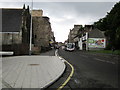
Wellmeadow Street, Paisley
From the junction at Lady Lane going towards Well Street.
Image: © Billy McCrorie
Taken: 14 Aug 2012
0.03 miles