IMAGES TAKEN NEAR TO
LOCHWINNOCH, PA12 4LB
Introduction
This page details the photographs taken nearby to PA12 4LB by members of the Geograph project.
The Geograph project started in 2005 with the aim of publishing, organising and preserving representative images for every square kilometre of Great Britain, Ireland and the Isle of Man.

There are currently over 7.5m images from over14,400 individuals and you can help contribute to the project by visiting https://www.geograph.org.uk
Image Map
Images are licensed for reuse under creativecommons.org/licenses/by-sa/2.0
Notes
- Clicking on the map will re-center to the selected point.
- The higher the marker number, the further away the image location is from the centre of the postcode.
Image Listing (5 Images Found)
Images are licensed for reuse under creativecommons.org/licenses/by-sa/2.0
Image
Details
Distance
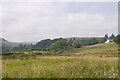
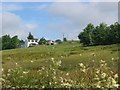
2
Calder Glen, Lochwinnoch
View towards Turnave Hill.
Image: © wfmillar
Taken: 25 Mar 2009
0.17 miles
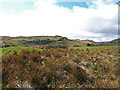
3
Calder Glen, Lochwinnoch
Looking towards Tandlemuir on the east side of the glen along a drainage ditch and drystone wall. The land is used mainly for sheep grazing.
Image: © wfmillar
Taken: 25 Mar 2009
0.18 miles
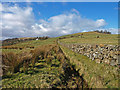
4
Tandlemuir
The further up the glen of the Calder, the wetter and poorer the land. Sheep grazing beyond a wet area growing meadowsweet (Filipendula ulmaria).
Image: © Richard Webb
Taken: 24 Jul 2005
0.18 miles