IMAGES TAKEN NEAR TO
Shields Holdings, LOCHWINNOCH, PA12 4HL
Introduction
This page details the photographs taken nearby to Shields Holdings, PA12 4HL by members of the Geograph project.
The Geograph project started in 2005 with the aim of publishing, organising and preserving representative images for every square kilometre of Great Britain, Ireland and the Isle of Man.

There are currently over 7.5m images from over14,400 individuals and you can help contribute to the project by visiting https://www.geograph.org.uk
Image Map
Images are licensed for reuse under creativecommons.org/licenses/by-sa/2.0
Notes
- Clicking on the map will re-center to the selected point.
- The higher the marker number, the further away the image location is from the centre of the postcode.
Image Listing (5 Images Found)
Images are licensed for reuse under creativecommons.org/licenses/by-sa/2.0
Image
Details
Distance
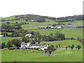
1
Pond and trackbed
The Lochwinnoch cycle path seen from Kenmure Hill.
Image: © Richard Webb
Taken: 17 Sep 2022
0.21 miles
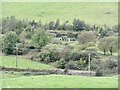
2
National Cycle Route No.7
This route takes you through some great country side. As it follows an old railway line sometimes you don't get the views to the full advantage. Taken from a higher vantage point a road bridge crossing the route.
Image: © wfmillar
Taken: 2 Oct 2008
0.24 miles
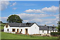
4
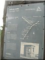
Information board
Information on Kenmuir Hill, its "temple" and the railway, situated beside National Cycle Route 7 on the Kilbarchan Loop railway trackbed.
Image: © Richard Webb
Taken: 13 Aug 2009
0.24 miles