IMAGES TAKEN NEAR TO
Beith Road, LOCHWINNOCH, PA12 4BU
Introduction
This page details the photographs taken nearby to Beith Road, PA12 4BU by members of the Geograph project.
The Geograph project started in 2005 with the aim of publishing, organising and preserving representative images for every square kilometre of Great Britain, Ireland and the Isle of Man.

There are currently over 7.5m images from over14,400 individuals and you can help contribute to the project by visiting https://www.geograph.org.uk
Image Map
Images are licensed for reuse under creativecommons.org/licenses/by-sa/2.0
Notes
- Clicking on the map will re-center to the selected point.
- The higher the marker number, the further away the image location is from the centre of the postcode.
Image Listing (8 Images Found)
Images are licensed for reuse under creativecommons.org/licenses/by-sa/2.0
Image
Details
Distance
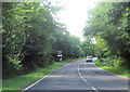
1
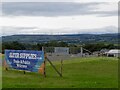
Alter Supplies, Park Farm
Off Clerksbridge Toll Roundabout.
Image: © Richard Webb
Taken: 17 Sep 2022
0.17 miles
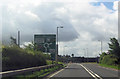
3
Clerksbridge Toll roundabout
Loanhead Quarry in the background.
Image: © Richard Webb
Taken: 17 Sep 2022
0.23 miles
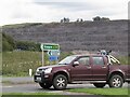
6
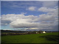
Farm
Rural view of Barrodger Farm, with view across Barr Loch to Barr Castle and Lochwinnoch.
Image: © Chris Court
Taken: 26 Nov 2005
0.24 miles
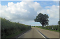
7
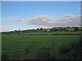
Barrodger Farm, Beith
New farm house built adjacent to old farm.
Image: © wfmillar
Taken: 19 Sep 2007
0.24 miles
8
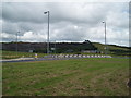
Clerksbridge Toll roundabout near Beith
Roundabout on A737 North of Beith, Loanhead Quarry in background. 26th July 2009 4.15p.m.
Image: © Gordon Dowie
Taken: 26 Jul 2009
0.25 miles