IMAGES TAKEN NEAR TO
Johnshill, LOCHWINNOCH, PA12 4AQ
Introduction
This page details the photographs taken nearby to Johnshill, PA12 4AQ by members of the Geograph project.
The Geograph project started in 2005 with the aim of publishing, organising and preserving representative images for every square kilometre of Great Britain, Ireland and the Isle of Man.

There are currently over 7.5m images from over14,400 individuals and you can help contribute to the project by visiting https://www.geograph.org.uk
Image Map
Images are licensed for reuse under creativecommons.org/licenses/by-sa/2.0
Notes
- Clicking on the map will re-center to the selected point.
- The higher the marker number, the further away the image location is from the centre of the postcode.
Image Listing (123 Images Found)
Images are licensed for reuse under creativecommons.org/licenses/by-sa/2.0
Image
Details
Distance
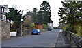
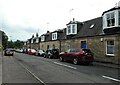
1
Johnshill, Lochwinnoch, Renfrewshire
From near the foot of Johnshill we are looking towards East End.
Image: © Mark S
Taken: 7 Nov 2020
0.00 miles
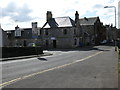
2
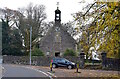
Auld Simon Kirk, Lochwinnoch, Renfrewshire
The clock tower located near the foot of Johnshill is all that remains of the Kirk of St John. The bell is said to be original and dates from 1729. The clock was added in 1731.
Image: © Mark S
Taken: 7 Nov 2020
0.03 miles
3
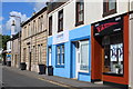
New building
On the corner of Johnshill and Mansfield Road. The recently constructed building has a curved frontage.
Image: © Richard Sutcliffe
Taken: 7 Jul 2023
0.05 miles
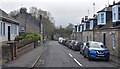
4
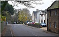
Johnshill, Lochwinnoch, Renfrewshire
The view looking up Johnshill.
Parkhill Drive is first on the right.
Image: © Mark S
Taken: 7 Nov 2020
0.07 miles
5
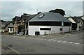
The Corner Bar, Lochwinnoch
Situated at the junction of Johnshill and St Winnoc Road.
Image: © Richard Sutcliffe
Taken: 24 Mar 2014
0.07 miles
6
St Winnoc Road, Lochwinnoch, Renfrewshire
The cottages on the right appear on an 1857 map of the village. The bungalow on the left was built in the mid-1980s.
Image: © Mark S
Taken: 7 Nov 2020
0.07 miles
7
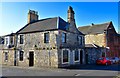
Corner Bar, Lochwinnoch, Renfrewshire
Located at the top end of High Street.
St. Winnoc road runs to the left.
Image: © Mark S
Taken: 21 Sep 2019
0.07 miles
9

St Winnoc Road
Previously known as Factory Close and later Factory Street.
Image: © Richard Sutcliffe
Taken: 7 Jul 2023
0.08 miles