IMAGES TAKEN NEAR TO
Lacy Street, PAISLEY, PA1 1GS
Introduction
This page details the photographs taken nearby to Lacy Street, PA1 1GS by members of the Geograph project.
The Geograph project started in 2005 with the aim of publishing, organising and preserving representative images for every square kilometre of Great Britain, Ireland and the Isle of Man.

There are currently over 7.5m images from over14,400 individuals and you can help contribute to the project by visiting https://www.geograph.org.uk
Image Map
Images are licensed for reuse under creativecommons.org/licenses/by-sa/2.0
Notes
- Clicking on the map will re-center to the selected point.
- The higher the marker number, the further away the image location is from the centre of the postcode.
Image Listing (107 Images Found)
Images are licensed for reuse under creativecommons.org/licenses/by-sa/2.0
Image
Details
Distance
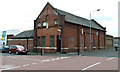
1
Booker Paisley
Foodservice wholesaler, located on Lacy Street.
Image: © Richard Sutcliffe
Taken: 27 Jan 2017
0.05 miles
2
Building on East Lane
Complete with ghost sign, at the corner of Lacy Street.
Image: © Thomas Nugent
Taken: 5 May 2014
0.07 miles
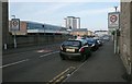
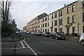
3
Lacy Street
From Seedhill Road. Blue building on the left is Booker Cash & Carry.
Image: © Billy McCrorie
Taken: 17 Jan 2012
0.07 miles
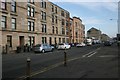
5
Tenements, Seedhill Road
Seen from the junction with Anchor Drive.
Image: © Richard Sutcliffe
Taken: 27 Jan 2017
0.09 miles
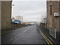
6
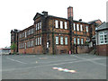
Williamsburgh Primary School
On Lacy Street, Viewed from East Lane.
Image: © Thomas Nugent
Taken: 5 May 2014
0.10 miles
7
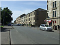
Seedhill Road
The shop at the corner of Lacy Street.
Image: © Thomas Nugent
Taken: 8 Jul 2013
0.10 miles
8
Seedhill Road
The shop is at the corner of Lacy Street.
Image: © Thomas Nugent
Taken: 8 Jul 2013
0.10 miles
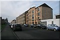
9
Tenement flats, Seedhill Road
Seen from beside the junction with Linside Avenue.
Image: © Richard Sutcliffe
Taken: 27 Jan 2017
0.11 miles
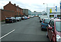
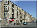
10
Tenements on Seedhill Road
The more recent of these tenement flats occupy the space of a former railway line, which crossed Seedhill Road on a bridge. The railway line (freight only) ran a few hundred metres to the north west to Paisley East station.
A house on the other side of the road [http://www.geograph.org.uk/photo/5265713] is skewed at an angle, indicating the direction of the bridge.
Image: © Richard Sutcliffe
Taken: 27 Jan 2017
0.11 miles