IMAGES TAKEN NEAR TO
Bracken Place, BRIDGE OF WEIR, PA11 3PE
Introduction
This page details the photographs taken nearby to Bracken Place, PA11 3PE by members of the Geograph project.
The Geograph project started in 2005 with the aim of publishing, organising and preserving representative images for every square kilometre of Great Britain, Ireland and the Isle of Man.

There are currently over 7.5m images from over14,400 individuals and you can help contribute to the project by visiting https://www.geograph.org.uk
Image Map
Images are licensed for reuse under creativecommons.org/licenses/by-sa/2.0
Notes
- Clicking on the map will re-center to the selected point.
- The higher the marker number, the further away the image location is from the centre of the postcode.
Image Listing (31 Images Found)
Images are licensed for reuse under creativecommons.org/licenses/by-sa/2.0
Image
Details
Distance
1
Houses on Gorse Crescent
Viewed from the cycle path.
Image: © Thomas Nugent
Taken: 14 Jun 2013
0.15 miles
2
Houses on Gorse Crescent
Viewed from the cycle path.
Image: © Thomas Nugent
Taken: 14 Jun 2013
0.15 miles
3
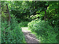
Path near Gorse Crescent
Running up the steep hill from Gorse Crescent to the A761 Bridge of Weir Road at St Mary's Scottish Episcopal Church.
Image: © Thomas Nugent
Taken: 14 Jun 2013
0.17 miles
4
National Cycle Network Route 75
Looking into the path at a gate from the grassed area behind Gorse Crescent.
Image: © Thomas Nugent
Taken: 14 Jun 2013
0.18 miles
5
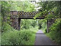
Bridge of Weir Railway
What would have been a double tracked section approaching Bridge of Weir Station. The line remained open until 1983 as far as Kilmacolm. The beautifully painted bridge is just opposite a church on Bridge of Weir Road.
The trackbed of the railway is now a cycle path (NCN 75). The railway was closed after a lengthy campaign to keep it open. There is growing demand for reconstruction and development such as housing on the trackbed has so far been prevented.
A photograph of the railway days: Image]
Image: © Richard Webb
Taken: 22 Jun 2009
0.19 miles
6
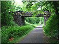
National Cycle Network Route 75
A shady spot alongside the A761 road, this is the footbridge opposite St Mary's Scottish Episcopal Church, looking west.
Image: © Thomas Nugent
Taken: 14 Jun 2013
0.19 miles
7
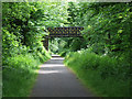
National Cycle Network Route 75
A shady spot alongside the A761 road, this is the footbridge opposite St Mary's Scottish Episcopal Church, looking east.
Image: © Thomas Nugent
Taken: 14 Jun 2013
0.19 miles
8
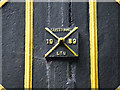
National Cycle Network Route 75
One of several "Sustrans 1989 Ltd" marks on the bridge opposite St Mary's Scottish Episcopal Church.
See also Image & Image
Image: © Thomas Nugent
Taken: 14 Jun 2013
0.19 miles
9
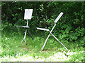
National Cycle Network Route 75
A pair of cleverly sculptured chairs in the form of two shovels.
A similar pair can be seen at nearby Johnstone Image
Image: © Thomas Nugent
Taken: 14 Jun 2013
0.19 miles
10

Bridge of Weir Station
View SE, towards Johnstone and Glasgow; ex-G&SW Glasgow (St Enoch) - Paisley - Elderslie - Greenock (Prince's Pier) line. Line closed to passengers Kilmacolm - Greenock 2/2/59, to goods 26/9/66. Elderslie - Kilmacolm not closed until 10/1/83, when Bridge of Weir closed. (High parapet of bridge prevented my getting a better picture, in pouring rain).
Image: © Ben Brooksbank
Taken: 26 Sep 1961
0.20 miles