IMAGES TAKEN NEAR TO
Church Manse Lane, BRIDGE OF WEIR, PA11 3NZ
Introduction
This page details the photographs taken nearby to Church Manse Lane, PA11 3NZ by members of the Geograph project.
The Geograph project started in 2005 with the aim of publishing, organising and preserving representative images for every square kilometre of Great Britain, Ireland and the Isle of Man.

There are currently over 7.5m images from over14,400 individuals and you can help contribute to the project by visiting https://www.geograph.org.uk
Image Map
Images are licensed for reuse under creativecommons.org/licenses/by-sa/2.0
Notes
- Clicking on the map will re-center to the selected point.
- The higher the marker number, the further away the image location is from the centre of the postcode.
Image Listing (98 Images Found)
Images are licensed for reuse under creativecommons.org/licenses/by-sa/2.0
Image
Details
Distance
1
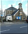
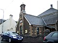
Freeland Church
A Category C listed church http://portal.historicenvironment.scot/designation/LB13481 on Main Street. The main part of the church dates from 1826. The front hall (including the bell tower) was added in 1857 (the gift of G S Freeland).
Image: © Richard Sutcliffe
Taken: 25 Mar 2022
0.03 miles
2
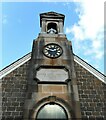
Bell tower, Freeland Church
A Category C listed church http://portal.historicenvironment.scot/designation/LB13481 on Main Street. The main part of the church dates from 1826. The front hall (including the bell tower) was added in 1857 (the gift of G S Freeland).
Image: © Richard Sutcliffe
Taken: 25 Mar 2022
0.03 miles
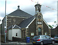
3

Freeland Church of Scotland, Main Street, Bridge of Weir
Category C-listed. Built 1826 to which the front hall, a gift of George Scott Freeland, was added in 1857.
Image: © Leslie Barrie
Taken: 6 Jul 2014
0.03 miles
5
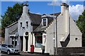
Former Bridge of Weir Post Office
The former Post Office building is now home to two fast food shops. The Post Office is now located in the former library, which is out of sight on the left at "The Bridge".
Image: © Thomas Nugent
Taken: 14 Jun 2013
0.03 miles
7
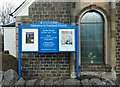
Notice board and window, Freeland Church
A Category C listed church http://portal.historicenvironment.scot/designation/LB13481 on Main Street. The main part of the church dates from 1826. The front hall (part seen here) was added in 1857 (the gift of G S Freeland).
Image: © Richard Sutcliffe
Taken: 25 Mar 2022
0.03 miles
8
Freeland Church
A category C listed building http://data.historic-scotland.gov.uk/pls/htmldb/f?p=2200:15:0::::BUILDING:13481 on Main Street.
Image: © Thomas Nugent
Taken: 14 Jun 2013
0.03 miles
9
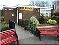
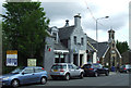
The Bridge Community Centre
More than just a community centre! The Bridge houses the Post Office, shop and cafe; and is home to the Horticultural Society, Community Garden, Bridge Club, Cinema, 'Brighter Bridge of Weir', and a hearing aid clinic. It also hosts the surgeries for Natalie Don MSP and Gavin Newlands MP.
Image: © Richard Sutcliffe
Taken: 25 Mar 2022
0.03 miles
10

Hope Hall
A non-denominational, elder-led church of Christians with a long history in Bridge of Weir.
Image: © Richard Sutcliffe
Taken: 25 Mar 2022
0.04 miles