IMAGES TAKEN NEAR TO
North View Road, BRIDGE OF WEIR, PA11 3EX
Introduction
This page details the photographs taken nearby to North View Road, PA11 3EX by members of the Geograph project.
The Geograph project started in 2005 with the aim of publishing, organising and preserving representative images for every square kilometre of Great Britain, Ireland and the Isle of Man.

There are currently over 7.5m images from over14,400 individuals and you can help contribute to the project by visiting https://www.geograph.org.uk
Image Map
Images are licensed for reuse under creativecommons.org/licenses/by-sa/2.0
Notes
- Clicking on the map will re-center to the selected point.
- The higher the marker number, the further away the image location is from the centre of the postcode.
Image Listing (20 Images Found)
Images are licensed for reuse under creativecommons.org/licenses/by-sa/2.0
Image
Details
Distance
1
Locher Road
Looking up the hill towards the tanneries and the south side of Bridge of Weir.
Image: © Thomas Nugent
Taken: 1 May 2020
0.07 miles
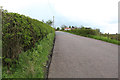
2
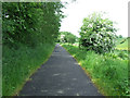
National Cycle Network Route 75
Heading west towards Bridge of Weir.
Image: © Thomas Nugent
Taken: 14 Jun 2013
0.07 miles
4
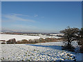
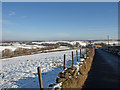
White fields near Ranfurly
The A761 runs along the bottom of this field to Bridge of Weir. The farm above the next field is Coalbog. With the expanding village of Crosslee to the left of Coalbeg. The hills in the distance are the Kilpatrick Hills left and the Campsie Hills centre.
Image: © wfmillar
Taken: 10 Feb 2009
0.09 miles
5
Crosslee Road, Ranfurly
Looking towards Glasgow in the far distance. The A761 at the bottom of field leading to bridge of Weir.
Image: © wfmillar
Taken: 10 Feb 2009
0.09 miles
6
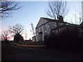
House on Kilbarchan Road
On the outskirts of Bridge of Weir.
Image: © Stephen Sweeney
Taken: 12 Feb 2012
0.10 miles
7
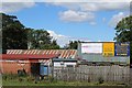
JL. Smith Construction, Kilbarchan Road
Image: © Alex McGregor
Taken: 7 Jun 2011
0.12 miles
8
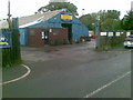
J L Smith Contractors Ltd, Bridge of Weir
Business premises on Kilbarchan Road
Image: © Leslie Barrie
Taken: 6 Jul 2014
0.13 miles
9
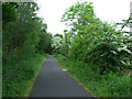
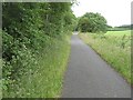
National Cycle Network Route 75
Between Crosslee Road and Bridge of Weir.
Image: © Thomas Nugent
Taken: 14 Jun 2013
0.13 miles
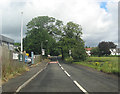
10
Bridge of Weir Railway
Approaching Bridge of Weir on what was once its commuter railway into Glasgow.
The trackbed of the railway is now a cycle path (NCN 75). The railway was closed in 1983 after a lengthy campaign to keep it open. There is growing demand for reconstruction and development such as housing on the trackbed has so far been prevented.
Image: © Richard Webb
Taken: 22 Jun 2009
0.15 miles