IMAGES TAKEN NEAR TO
Hazelwood Road, BRIDGE OF WEIR, PA11 3DJ
Introduction
This page details the photographs taken nearby to Hazelwood Road, PA11 3DJ by members of the Geograph project.
The Geograph project started in 2005 with the aim of publishing, organising and preserving representative images for every square kilometre of Great Britain, Ireland and the Isle of Man.

There are currently over 7.5m images from over14,400 individuals and you can help contribute to the project by visiting https://www.geograph.org.uk
Image Map
Images are licensed for reuse under creativecommons.org/licenses/by-sa/2.0
Notes
- Clicking on the map will re-center to the selected point.
- The higher the marker number, the further away the image location is from the centre of the postcode.
Image Listing (25 Images Found)
Images are licensed for reuse under creativecommons.org/licenses/by-sa/2.0
Image
Details
Distance
1
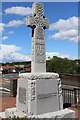
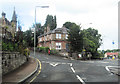
Castle Terrace
The Category B Listed Castle Terrace http://data.historic-scotland.gov.uk/pls/htmldb/f?p=2200:15:0::::BUILDING:12959 , viewed from the Main Street bridge.
Image: © Thomas Nugent
Taken: 14 Jun 2013
0.20 miles
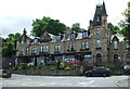
2
Clydesdale Bank, Bridge of Weir
On a prominent site at the junction of Main Street and Prieston Road.
Image: © Thomas Nugent
Taken: 14 Jun 2013
0.21 miles
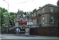
3
Main Street, Bridge of Weir
The Category B Listed Castle Terrace http://data.historic-scotland.gov.uk/pls/htmldb/f?p=2200:15:0::::BUILDING:12959 is in the background. The bridge in the foreground crosses the former Glasgow to Princes Pier railway line.
Image: © Thomas Nugent
Taken: 14 Jun 2013
0.21 miles
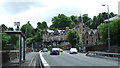
4
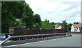
A761 Road Bridge, Bridge of Weir
Crossing cycleway 75 on dismantled railway line. Note the extra support on the bridge.
Image: © wfmillar
Taken: 29 Mar 2009
0.21 miles
5
A761 crossing the former railway at Bridge of Weir
Image: © Elliott Simpson
Taken: 18 May 2012
0.21 miles
6
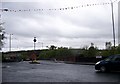
Main road junction at Bridge of Weir
From Kilbarchan Road
Image: © John Firth
Taken: 28 Jul 2012
0.21 miles
7
Main Street, Bridge of Weir
The bridge over the former Glasgow to Princes Pier railway line.
Image: © Thomas Nugent
Taken: 14 Jun 2013
0.22 miles
8
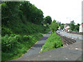
National Cycle Network Route 75
Bridge of Weir Main Street is on the right.
Image: © Thomas Nugent
Taken: 14 Jun 2013
0.22 miles
9
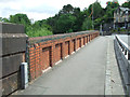
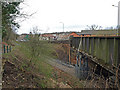
Old railway bridge
The bridge carries the A761 Main Street over the former Glasgow to Princes Pier railway line.
Image: © Thomas Nugent
Taken: 14 Jun 2013
0.22 miles