IMAGES TAKEN NEAR TO
Gryffe Road, BRIDGE OF WEIR, PA11 3AL
Introduction
This page details the photographs taken nearby to Gryffe Road, PA11 3AL by members of the Geograph project.
The Geograph project started in 2005 with the aim of publishing, organising and preserving representative images for every square kilometre of Great Britain, Ireland and the Isle of Man.

There are currently over 7.5m images from over14,400 individuals and you can help contribute to the project by visiting https://www.geograph.org.uk
Image Map
Images are licensed for reuse under creativecommons.org/licenses/by-sa/2.0
Notes
- Clicking on the map will re-center to the selected point.
- The higher the marker number, the further away the image location is from the centre of the postcode.
Image Listing (86 Images Found)
Images are licensed for reuse under creativecommons.org/licenses/by-sa/2.0
Image
Details
Distance
1

Waterfall on the Glendentan Burn
The Glendentan Burn joins the Pow Burn just downstream from here.
Image: © Richard Sutcliffe
Taken: 25 Mar 2022
0.08 miles
2
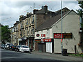
Main Street, Bridge of Weir
A wide range of shops facing the former Glasgow to Princes Pier railway line.
Image: © Thomas Nugent
Taken: 14 Jun 2013
0.08 miles
3
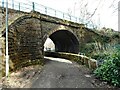
Old railway bridge over a path and the Pow Burn
Built by the Greenock and Ayrshire Railway and opened in 1869. The railway line now forms part of National Cycle Route 75. The footpath under the railway leads onto Main Street.
Image: © Richard Sutcliffe
Taken: 25 Mar 2022
0.08 miles
4
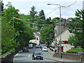
Main Street, Bridge of Weir
Looking west from the old railway bridge.
Image: © Thomas Nugent
Taken: 14 Jun 2013
0.08 miles
6
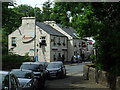
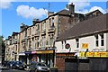
Main Street, Bridge of Weir
The Amaretto restaurant is prominent. This was formerly The Railway Tavern.
Image: © Thomas Nugent
Taken: 14 Jun 2013
0.09 miles
7
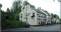
Amaretto Restaurant
The Amaretto restaurant was formerly known as The Railway Tavern and is now under new ownership. The former Glasgow to Princes Pier railway line can be seen on the left.
Image: © Thomas Nugent
Taken: 14 Jun 2013
0.09 miles
8
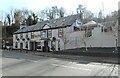
Amaretto
Italian Kitchen and Bar on Main Street, Bridge of Weir.
Image: © Richard Sutcliffe
Taken: 25 Mar 2022
0.09 miles
9
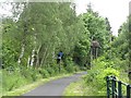
Greenock and Ayrshire Railway
West of Bridge of Weir station the railway was developed by the Greenock and Ayrshire Railway. The line was open as far as Kilmacolm until 1983. Now National Cycle Network route 75.
Image: © Richard Webb
Taken: 22 Jun 2009
0.09 miles
10
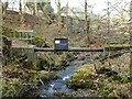
Pipe bridge
A pipe bridge over the Pow Burn.
Image: © Richard Sutcliffe
Taken: 25 Mar 2022
0.10 miles