IMAGES TAKEN NEAR TO
Kilbarchan, JOHNSTONE, PA10 2PZ
Introduction
This page details the photographs taken nearby to PA10 2PZ by members of the Geograph project.
The Geograph project started in 2005 with the aim of publishing, organising and preserving representative images for every square kilometre of Great Britain, Ireland and the Isle of Man.

There are currently over 7.5m images from over14,400 individuals and you can help contribute to the project by visiting https://www.geograph.org.uk
Image Map
Images are licensed for reuse under creativecommons.org/licenses/by-sa/2.0
Notes
- Clicking on the map will re-center to the selected point.
- The higher the marker number, the further away the image location is from the centre of the postcode.
Image Listing (6 Images Found)
Images are licensed for reuse under creativecommons.org/licenses/by-sa/2.0
Image
Details
Distance
2
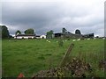
Road to Auchencloich Farms
Approaching from the east.
Image: © Stephen Sweeney
Taken: 12 Feb 2012
0.04 miles
3
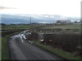
Minor Road, near Auchencloich Farms.
The road could be doing with some repair. Barnbrock Farm in the distance.
Image: © wfmillar
Taken: 29 Mar 2009
0.18 miles
5
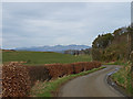
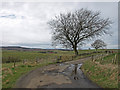
Minor Road, near Auchencloich Farms
Great view point looking north to the hills beyond Dunoon and Helensburgh. The centre of frame could be Beinn Chaorach. You can just see a few snow covered peaks to the right, possibly Beinn Ime or The Cobbler. Well trimmed beech hedge on the left of road and mixed plantation on the right.
Image: © wfmillar
Taken: 29 Mar 2009
0.20 miles
