IMAGES TAKEN NEAR TO
Shuttle Street, JOHNSTONE, PA10 2PR
Introduction
This page details the photographs taken nearby to Shuttle Street, PA10 2PR by members of the Geograph project.
The Geograph project started in 2005 with the aim of publishing, organising and preserving representative images for every square kilometre of Great Britain, Ireland and the Isle of Man.

There are currently over 7.5m images from over14,400 individuals and you can help contribute to the project by visiting https://www.geograph.org.uk
Image Map (Loading...)


Getting Data...Please wait
Leaflet Map data © OpenStreetMap
Images are licensed for reuse under creativecommons.org/licenses/by-sa/2.0
Notes
- Clicking on the map will re-center to the selected point.
- The higher the marker number, the further away the image location is from the centre of the postcode.
Image Listing (6 Images Found)
Images are licensed for reuse under creativecommons.org/licenses/by-sa/2.0
Image
Details
Distance
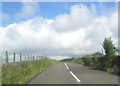
1
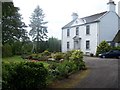
Locher Road at Forehouse
Ward House riding stables to the right
Image: © John Firth
Taken: 28 Jul 2012
0.04 miles
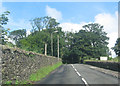
2
Sign for Wardhouse Riding School by Locher Road
At the junction with Forehouse Road
Image: © Leslie Barrie
Taken: 6 Jul 2014
0.06 miles
3
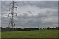
Pylon line above Kilbarchan
The line carries electricity across the M8 and the River Clyde at Erskine.
Image: © Alan Reid
Taken: 16 Oct 2016
0.12 miles
5
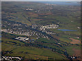
Bridge of Weir from the air
Kilmacolm, Port Glasgow and the Firth of Clyde are in the distance. Part of Kilbarchan is in the foreground.
Image: © Thomas Nugent
Taken: 9 Dec 2019
0.17 miles