IMAGES TAKEN NEAR TO
Burnside Gardens, JOHNSTONE, PA10 2HQ
Introduction
This page details the photographs taken nearby to Burnside Gardens, PA10 2HQ by members of the Geograph project.
The Geograph project started in 2005 with the aim of publishing, organising and preserving representative images for every square kilometre of Great Britain, Ireland and the Isle of Man.

There are currently over 7.5m images from over14,400 individuals and you can help contribute to the project by visiting https://www.geograph.org.uk
Image Map
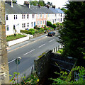
Images are licensed for reuse under creativecommons.org/licenses/by-sa/2.0
Notes
- Clicking on the map will re-center to the selected point.
- The higher the marker number, the further away the image location is from the centre of the postcode.
Image Listing (56 Images Found)
Images are licensed for reuse under creativecommons.org/licenses/by-sa/2.0
Image
Details
Distance
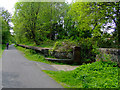
1

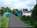
National Cycle Network Route 7
The remains of Kilbarchan station.
Image: © Thomas Nugent
Taken: 29 Apr 2011
0.05 miles
2
National Cycle Network Route 7
At the site of Kilbarchan railway station.
Image: © Thomas Nugent
Taken: 29 Apr 2011
0.05 miles

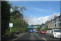
5
National Cycle Network Route 7
The ramp from Easwald Bank up to the site of Kilbarchan station.
Image: © Thomas Nugent
Taken: 29 Apr 2011
0.06 miles
6
Former railway station, Kilbarchan
Kilbarchan railway station was opened in 1905 by the Glasgow and South Western Railway. The station closed to passengers in 1966 and the line closed completely in 1971.
The course of the railway is now part of the Sustrans Cycle Route 7.
Image: © Richard Sutcliffe
Taken: 5 Feb 2020
0.06 miles
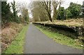
7
Easwald Bank
Viewed from National Cycle Network Route 7.
Image: © Thomas Nugent
Taken: 29 Apr 2011
0.06 miles
8
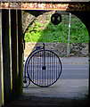
National Cycle Network Route 7
A penny-farthing sculpture at the entrance to the former Kilbarchan station. Note also the thistle hanging above.
Image: © Thomas Nugent
Taken: 29 Apr 2011
0.07 miles
9
Former railway bridge, now part of National Cycle Route 7
The National Cycle Route from Sunderland to Inverness approaches Glasgow from the southwest, after following the coast to Irvine. It was formerly the Dalry and North Johnstone railway line, but like many of Britain's railways the line closed in the 1960s.
Image: © Stephen Sweeney
Taken: 11 May 2011
0.07 miles
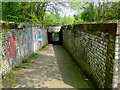
10
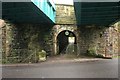
Double railway bridge, Kilbarchan
The subway leads up to the former Kilbarchan railway station, which opened in 1905, operated by the Glasgow and South Western Railway. The station closed to passengers in 1966 and the line closed completely in 1971.
The course of the railway is now part of the Sustrans Cycle Route 7, which is why the number '7' and a 'penny farthing' are at the entrance to the subway.
Image: © Richard Sutcliffe
Taken: 5 Feb 2020
0.07 miles