IMAGES TAKEN NEAR TO
Stoke Talmage Road, THAME, OX9 7EP
Introduction
This page details the photographs taken nearby to Stoke Talmage Road, OX9 7EP by members of the Geograph project.
The Geograph project started in 2005 with the aim of publishing, organising and preserving representative images for every square kilometre of Great Britain, Ireland and the Isle of Man.

There are currently over 7.5m images from over14,400 individuals and you can help contribute to the project by visiting https://www.geograph.org.uk
Image Map
Images are licensed for reuse under creativecommons.org/licenses/by-sa/2.0
Notes
- Clicking on the map will re-center to the selected point.
- The higher the marker number, the further away the image location is from the centre of the postcode.
Image Listing (7 Images Found)
Images are licensed for reuse under creativecommons.org/licenses/by-sa/2.0
Image
Details
Distance
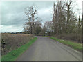
2
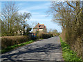
Lane from Stoke Talmage
Lane from Stoke Talmage heading towards Wheatfield Cottages
Image: © Shaun Ferguson
Taken: 3 May 2008
0.01 miles
3
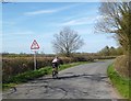
He'll Go Under
Cyclist passing a height restriction sign on the road to Tetsworth.
Image: © Des Blenkinsopp
Taken: 23 Apr 2013
0.08 miles
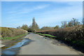
4
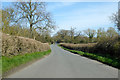
Road towards Tetsworth
From Stoke Talmage.
Image: © Robin Webster
Taken: 22 Mar 2020
0.10 miles
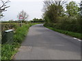
5
Lane junction for Adwell and South Weston
Image: © Stuart Logan
Taken: 8 Apr 2012
0.13 miles
6
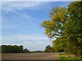
Farmland, Wheatfield
A view from the Oxfordshire Way between Tetsworth and Adwell.
Image: © Andrew Smith
Taken: 1 Oct 2011
0.21 miles
7
Road towards Tetsworth
From Stoke Talmage.
Image: © Robin Webster
Taken: 22 Mar 2020
0.22 miles