IMAGES TAKEN NEAR TO
Thame Road, THAME, OX9 7DE
Introduction
This page details the photographs taken nearby to Thame Road, OX9 7DE by members of the Geograph project.
The Geograph project started in 2005 with the aim of publishing, organising and preserving representative images for every square kilometre of Great Britain, Ireland and the Isle of Man.

There are currently over 7.5m images from over14,400 individuals and you can help contribute to the project by visiting https://www.geograph.org.uk
Image Map
Images are licensed for reuse under creativecommons.org/licenses/by-sa/2.0
Notes
- Clicking on the map will re-center to the selected point.
- The higher the marker number, the further away the image location is from the centre of the postcode.
Image Listing (5 Images Found)
Images are licensed for reuse under creativecommons.org/licenses/by-sa/2.0
Image
Details
Distance
3
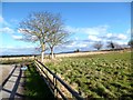
Upper Copcourt farm
Footpath nearing Upper Copcourt farm
Image: © Shaun Ferguson
Taken: 22 Oct 2008
0.06 miles
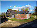
5
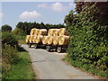
Harvest home! - straw bales arrive at Upper Copcourt Farm
Combine harvesters take the grain, and pack the straw in these round bales. Farms collect them with lorries, trailers, fork lift trucks, JCBs. Often the straw bales then pile up in the farmyard for years.
Image: © David Hawgood
Taken: 16 Aug 2005
0.15 miles