IMAGES TAKEN NEAR TO
Tetsworth, THAME, OX9 7BT
Introduction
This page details the photographs taken nearby to OX9 7BT by members of the Geograph project.
The Geograph project started in 2005 with the aim of publishing, organising and preserving representative images for every square kilometre of Great Britain, Ireland and the Isle of Man.

There are currently over 7.5m images from over14,400 individuals and you can help contribute to the project by visiting https://www.geograph.org.uk
Image Map
Images are licensed for reuse under creativecommons.org/licenses/by-sa/2.0
Notes
- Clicking on the map will re-center to the selected point.
- The higher the marker number, the further away the image location is from the centre of the postcode.
Image Listing (14 Images Found)
Images are licensed for reuse under creativecommons.org/licenses/by-sa/2.0
Image
Details
Distance
1
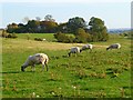
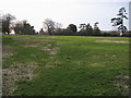
Pasture, Tetsworth
Sheep grazing to the south of Manor Farm.
Image: © Andrew Smith
Taken: 1 Oct 2011
0.12 miles
2
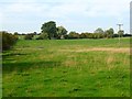
Pasture, Tetsworth
The footpath west of Oxhouse Farm follows this former field boundary.
Image: © Andrew Smith
Taken: 5 Feb 2023
0.19 miles
3
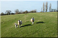
Pasture, Tetsworth
The bridleway to the west of Harlesford House follows the left edge of these fields.
Image: © Andrew Smith
Taken: 1 Oct 2011
0.22 miles
4
Bridleway to Manor Farm
Bridleway to Manor Farm and Goldpits Farm
Image: © Shaun Ferguson
Taken: 15 Mar 2009
0.22 miles
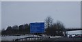
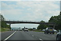
6
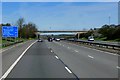
Minor Bridge Over the M40 near Tetsworth
Image: © David Dixon
Taken: 17 May 2013
0.23 miles
9
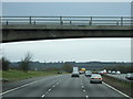
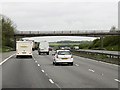
Passing under a farm road on the M40 near Tetsworth
Image: © JThomas
Taken: 9 Mar 2012
0.23 miles