IMAGES TAKEN NEAR TO
Lacey Drive, THAME, OX9 3UU
Introduction
This page details the photographs taken nearby to Lacey Drive, OX9 3UU by members of the Geograph project.
The Geograph project started in 2005 with the aim of publishing, organising and preserving representative images for every square kilometre of Great Britain, Ireland and the Isle of Man.

There are currently over 7.5m images from over14,400 individuals and you can help contribute to the project by visiting https://www.geograph.org.uk
Image Map
Images are licensed for reuse under creativecommons.org/licenses/by-sa/2.0
Notes
- Clicking on the map will re-center to the selected point.
- The higher the marker number, the further away the image location is from the centre of the postcode.
Image Listing (34 Images Found)
Images are licensed for reuse under creativecommons.org/licenses/by-sa/2.0
Image
Details
Distance
1
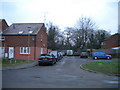
Lacey Drive, Thame
A very short cul de sac off Pearce Way.
Image: © Richard Vince
Taken: 26 Jan 2019
0.02 miles
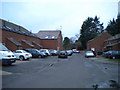
3
Walker Drive, Thame
A very short cul de sac off Pearce Way
Image: © Richard Vince
Taken: 26 Jan 2019
0.03 miles
4
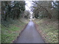
Phoenix Trail, Thame (2)
Providing a traffic free route for cyclists and pedestrians along the former railway formation between Thame and Princes Risborough. Looking towards Princes Risborough as it approaches the Thame bypass.
Image: © Richard Vince
Taken: 26 Jan 2019
0.04 miles
5
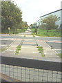
Railway gone but the rails remain across the B4012
A remnant of the long gone Princes Risborough to Thame railway with the trackbed now a cycle path.
Image: © Roger Templeman
Taken: 3 Nov 2010
0.06 miles
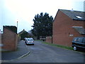
6
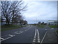
Howland Road, Thame
Part of the bypass around the eastern edge of the town, now providing access to a business park.
Image: © Richard Vince
Taken: 26 Jan 2019
0.07 miles
7
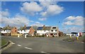
Loft Lights or Solar Panels?
What to do with the roof. Decisions, decisions....
Looks to be three all with one abstention here on these houses on the edge of Thame.
Image: © Des Blenkinsopp
Taken: 27 Feb 2015
0.07 miles
8
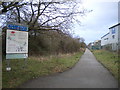
Phoenix Trail east of Thame (1)
Providing a traffic free route for cyclists and pedestrians along the former railway formation between Thame and Princes Risborough. This view is immediately east of the Thame bypass, where the trail leaves the town proper and passes between industrial units.
Image: © Richard Vince
Taken: 26 Jan 2019
0.08 miles
9
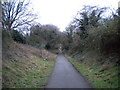
Phoenix Trail, Thame (1)
Providing a traffic free route for cyclists and pedestrians along the former railway formation between Thame and Princes Risborough. Seen here in the eastern suburbs of Thame, looking towards the town centre.
Image: © Richard Vince
Taken: 26 Jan 2019
0.08 miles
10
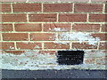
Benchmark on #11 Garden City
Ordnance Survey cut mark benchmark described on the Bench Mark Database at http://www.bench-marks.org.uk/bm35898
Image: © Roger Templeman
Taken: 3 Nov 2010
0.08 miles