IMAGES TAKEN NEAR TO
Towersey Road, THAME, OX9 3UR
Introduction
This page details the photographs taken nearby to Towersey Road, OX9 3UR by members of the Geograph project.
The Geograph project started in 2005 with the aim of publishing, organising and preserving representative images for every square kilometre of Great Britain, Ireland and the Isle of Man.

There are currently over 7.5m images from over14,400 individuals and you can help contribute to the project by visiting https://www.geograph.org.uk
Image Map
Images are licensed for reuse under creativecommons.org/licenses/by-sa/2.0
Notes
- Clicking on the map will re-center to the selected point.
- The higher the marker number, the further away the image location is from the centre of the postcode.
Image Listing (16 Images Found)
Images are licensed for reuse under creativecommons.org/licenses/by-sa/2.0
Image
Details
Distance
2
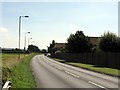
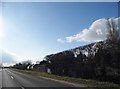
B4012 Howland Road, Thame
An eastern by-pass of the town.
Image: © Robin Webster
Taken: 20 Oct 2018
0.04 miles
3
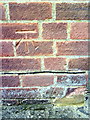
Benchmark on garage of #1 Towersey Drive
Ordnance Survey cut mark benchmark described on the Bench Mark Database at http://www.bench-marks.org.uk/bm35899
Image: © Roger Templeman
Taken: 3 Nov 2010
0.09 miles
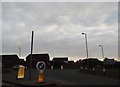
5

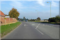
Roundabout at the end of Tythrop Way, Thame
Image: © David Howard
Taken: 20 Mar 2016
0.18 miles
6
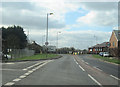
Roundabout at the end of Tythrop Way, Thame
Tythrop Way acts as a bypass to avoid the middle of Thame
Image: © David Howard
Taken: 20 Mar 2016
0.19 miles
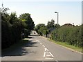
9
Kingsey Road entering Thame
On the right are allotments
Image: © David Howard
Taken: 20 Mar 2016
0.20 miles
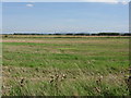
10
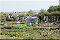
Kingsey Road Allotments
On the edge of Thame with a distant view of the Chilterns.
Image: © Bill Boaden
Taken: 20 Apr 2019
0.21 miles