IMAGES TAKEN NEAR TO
Cotmore Close, THAME, OX9 3NE
Introduction
This page details the photographs taken nearby to Cotmore Close, OX9 3NE by members of the Geograph project.
The Geograph project started in 2005 with the aim of publishing, organising and preserving representative images for every square kilometre of Great Britain, Ireland and the Isle of Man.

There are currently over 7.5m images from over14,400 individuals and you can help contribute to the project by visiting https://www.geograph.org.uk
Image Map
Images are licensed for reuse under creativecommons.org/licenses/by-sa/2.0
Notes
- Clicking on the map will re-center to the selected point.
- The higher the marker number, the further away the image location is from the centre of the postcode.
Image Listing (24 Images Found)
Images are licensed for reuse under creativecommons.org/licenses/by-sa/2.0
Image
Details
Distance
1
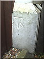
Benchmark on #111 Chinnor Road
Ordnance Survey cut mark benchmark described on the Bench Mark Database at http://www.bench-marks.org.uk/bm35897
Image: © Roger Templeman
Taken: 3 Nov 2010
0.09 miles
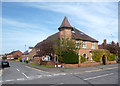
4
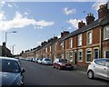
Chinnor Road, Thame
The B4445 towards the town centre.
Image: © Robin Webster
Taken: 20 Oct 2018
0.12 miles
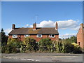
5
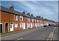
Chinnor Road, Thame
I had noticed these terraced cottages before, when passing through. They look as if they were built to house a growing industrial population, and I'd been wondering which industry it was that led to the expansion of the town along the Chinnor road - perhaps circa 1890. A glance at the map shows that the area on the other (south) side of the road used to be railway land - so that answers my query, at least in part.
I'm left wondering whether the terraced cottages were built by or for a railway company. In any case, some 120 years or so later, the decorative brickwork gives the terrace a character of its own, and makes this an attractive street. The modern residential development on the old railway site contributes much less to the townscape.
Image: © Stefan Czapski
Taken: 17 Aug 2014
0.12 miles
6
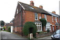
Terraced Houses, Chinnor Road
Standard terraced housing but with fine decorative brickwork on doors, windows and chimneys. Enhancement by some of the owners adds to the effect.
Image: © Des Blenkinsopp
Taken: 23 Apr 2013
0.13 miles
7
#45 Queens Road
There is an OS benchmark Image on the side wall of the house at the junction with the boundary wall
Image: © Roger Templeman
Taken: 8 Oct 2013
0.13 miles
8
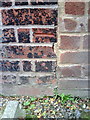
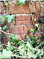
Benchmark on #45 Queens Road
Ordnance Survey cut mark benchmark described on the Bench Mark Database at http://www.bench-marks.org.uk/bm35912
Image: © Roger Templeman
Taken: 3 Nov 2010
0.13 miles
9
Benchmark on #46 Queens Road
Ordnance Survey cut mark benchmark described on the Bench Mark Database at http://www.bench-marks.org.uk/bm35911
Image: © Roger Templeman
Taken: 3 Nov 2010
0.13 miles
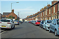
10
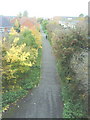
Track bed of former railway west from Thame station
View from the bridge on Chinnor Road.
Image: © Roger Templeman
Taken: 3 Nov 2010
0.14 miles