IMAGES TAKEN NEAR TO
Cotmore Gardens, THAME, OX9 3LZ
Introduction
This page details the photographs taken nearby to Cotmore Gardens, OX9 3LZ by members of the Geograph project.
The Geograph project started in 2005 with the aim of publishing, organising and preserving representative images for every square kilometre of Great Britain, Ireland and the Isle of Man.

There are currently over 7.5m images from over14,400 individuals and you can help contribute to the project by visiting https://www.geograph.org.uk
Image Map
Images are licensed for reuse under creativecommons.org/licenses/by-sa/2.0
Notes
- Clicking on the map will re-center to the selected point.
- The higher the marker number, the further away the image location is from the centre of the postcode.
Image Listing (37 Images Found)
Images are licensed for reuse under creativecommons.org/licenses/by-sa/2.0
Image
Details
Distance
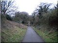
3
Track bed of former railway west from Thame station
View from the bridge on Chinnor Road.
Image: © Roger Templeman
Taken: 3 Nov 2010
0.08 miles
4
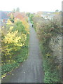
The Phoenix Trail enters Thame
As this cycle track enters Thame, a former railway platform is on the left, light industry on the right, a road bridge ahead.
Image: © David Hawgood
Taken: 2 Aug 2005
0.09 miles
5
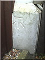
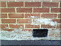
Benchmark on #111 Chinnor Road
Ordnance Survey cut mark benchmark described on the Bench Mark Database at http://www.bench-marks.org.uk/bm35897
Image: © Roger Templeman
Taken: 3 Nov 2010
0.11 miles
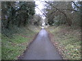
6
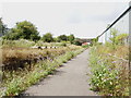
Phoenix Trail, Thame (1)
Providing a traffic free route for cyclists and pedestrians along the former railway formation between Thame and Princes Risborough. Seen here in the eastern suburbs of Thame, looking towards the town centre.
Image: © Richard Vince
Taken: 26 Jan 2019
0.12 miles
7
Phoenix Trail, Thame (2)
Providing a traffic free route for cyclists and pedestrians along the former railway formation between Thame and Princes Risborough. Looking towards Princes Risborough as it approaches the Thame bypass.
Image: © Richard Vince
Taken: 26 Jan 2019
0.15 miles
9
Benchmark on #11 Garden City
Ordnance Survey cut mark benchmark described on the Bench Mark Database at http://www.bench-marks.org.uk/bm35898
Image: © Roger Templeman
Taken: 3 Nov 2010
0.17 miles
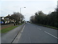
10

Chinnor Road, Thame
The B4445 towards the town centre.
Image: © Robin Webster
Taken: 20 Oct 2018
0.17 miles