IMAGES TAKEN NEAR TO
Pickenfield, THAME, OX9 3HG
Introduction
This page details the photographs taken nearby to Pickenfield, OX9 3HG by members of the Geograph project.
The Geograph project started in 2005 with the aim of publishing, organising and preserving representative images for every square kilometre of Great Britain, Ireland and the Isle of Man.

There are currently over 7.5m images from over14,400 individuals and you can help contribute to the project by visiting https://www.geograph.org.uk
Image Map
Images are licensed for reuse under creativecommons.org/licenses/by-sa/2.0
Notes
- Clicking on the map will re-center to the selected point.
- The higher the marker number, the further away the image location is from the centre of the postcode.
Image Listing (23 Images Found)
Images are licensed for reuse under creativecommons.org/licenses/by-sa/2.0
Image
Details
Distance
1

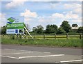
Office on the edge of Thame
Business units and housing crowd up to the edge of the ring road.
It won't be long before that crucial leap over the tarmac.
Image: © Des Blenkinsopp
Taken: 19 May 2014
0.08 miles
2

Daf offices on Howland Road
The Daf cars were taken over by Volvo in the 80s, but the commercial vehicles remain.
Image: © David Howard
Taken: 20 Mar 2016
0.08 miles
3
The Builders Are Coming
At the moment Thame stops at the ring road, and land to the east is still rural.
It doesn't look like that's going to last much longer.
Image: © Des Blenkinsopp
Taken: 19 May 2014
0.12 miles
4

Groves
A newly constructed site for this needlecraft distribution business.
Image: © Bill Boaden
Taken: 20 Apr 2019
0.15 miles
5
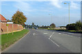
B4012 Howland Road, Thame
An eastern by-pass of the town.
Image: © Robin Webster
Taken: 20 Oct 2018
0.15 miles
6
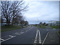
Howland Road, Thame
Part of the bypass around the eastern edge of the town, now providing access to a business park.
Image: © Richard Vince
Taken: 26 Jan 2019
0.16 miles
7
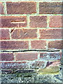
Benchmark on garage of #1 Towersey Drive
Ordnance Survey cut mark benchmark described on the Bench Mark Database at http://www.bench-marks.org.uk/bm35899
Image: © Roger Templeman
Taken: 3 Nov 2010
0.17 miles
8
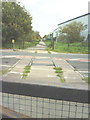
Railway gone but the rails remain across the B4012
A remnant of the long gone Princes Risborough to Thame railway with the trackbed now a cycle path.
Image: © Roger Templeman
Taken: 3 Nov 2010
0.17 miles
9
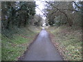
Phoenix Trail, Thame (2)
Providing a traffic free route for cyclists and pedestrians along the former railway formation between Thame and Princes Risborough. Looking towards Princes Risborough as it approaches the Thame bypass.
Image: © Richard Vince
Taken: 26 Jan 2019
0.18 miles
10
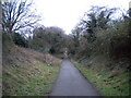
Phoenix Trail, Thame (1)
Providing a traffic free route for cyclists and pedestrians along the former railway formation between Thame and Princes Risborough. Seen here in the eastern suburbs of Thame, looking towards the town centre.
Image: © Richard Vince
Taken: 26 Jan 2019
0.18 miles